Ecosyste.ms: Awesome
An open API service indexing awesome lists of open source software.
https://github.com/jorelosorio/web-mercator-projection
A Go project to explore the math to calculate and present data in a map using the `Web Mercator Projection`
https://github.com/jorelosorio/web-mercator-projection
geolocation geospatial golang golang-library google-mercator-projection image-processing imagemagick map maps openstreetmap web-mercator
Last synced: about 1 month ago
JSON representation
A Go project to explore the math to calculate and present data in a map using the `Web Mercator Projection`
- Host: GitHub
- URL: https://github.com/jorelosorio/web-mercator-projection
- Owner: jorelosorio
- License: gpl-3.0
- Created: 2022-03-16T20:19:56.000Z (about 2 years ago)
- Default Branch: main
- Last Pushed: 2022-03-24T20:30:37.000Z (about 2 years ago)
- Last Synced: 2024-01-30T09:15:46.640Z (4 months ago)
- Topics: geolocation, geospatial, golang, golang-library, google-mercator-projection, image-processing, imagemagick, map, maps, openstreetmap, web-mercator
- Language: Go
- Homepage:
- Size: 3.31 MB
- Stars: 5
- Watchers: 1
- Forks: 1
- Open Issues: 0
-
Metadata Files:
- Readme: README.md
- License: LICENSE
Lists
- awesome-go - Web-Mercator-Projection
- awesome-go - Web-Mercator-Projection
- awesome-go-extra - web-mercator-projection - 03-16T20:19:56Z|2022-03-24T20:30:37Z| (Geographic / Advanced Console UIs)
- awesome-go - Web-Mercator-Projection
- awesome-go-cn - Web-Mercator-Projection
- awesome-go - Web-Mercator-Projection
- awesome-go - Web-Mercator-Projection
- awesome-go-cn - Web-Mercator-Projection
- awesome-go-stars - Web-Mercator-Projection
- awesome-go-with-stars - Web-Mercator-Projection
- repo-1316-awesome-go-cn - Web-Mercator-Projection
- repo-1211-awesome-go-cn - Web-Mercator-Projection
- Go-awesome - Web-Mercator-Projection
- awesome-go - Web-Mercator-Projection
- awesome-go-zh - Web-Mercator-Projection
- awesome-go - Web-Mercator-Projection
- awesome-go - Web-Mercator-Projection
README
# Web Mercator Projection
[](https://github.com/jorelosorio/web-mercator-projection/actions/workflows/tests.yml)
[](https://goreportcard.com/report/github.com/jorelosorio/web-mercator-projection)
[](https://coveralls.io/github/jorelosorio/web-mercator-projection?branch=main)
[](https://pkg.go.dev/github.com/jorelosorio/web-mercator-projection)
A Go project to explore the `Math` to calculate and present data in a map using the `Web Mercator Projection`.
> To get more information about this topic, please look at the following references:
- https://en.wikipedia.org/wiki/Web_Mercator_projection
- https://www.maptiler.com/google-maps-coordinates-tile-bounds-projection/#3/15.00/50.00
- https://wiki.openstreetmap.org/wiki/Slippy_map_tilenames
## How does this project work?
In the main example project, there is a file `main.go` that contains the following actions available:
- Convert a `LonLat` into a `Point` coordinates and vice versa.
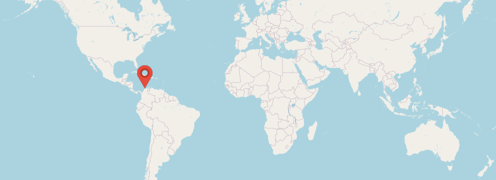
- A function to add a `Red-Marker` into a map image. (The coordinates must be setted manually in the code)
> The resultant image will be stored in a folder named `data`.
This is how the `main.go` will print out the information:
LonLat: {-74.92010258781309 11.045882360336755}
Point: {298.8939304168872 480.38414652354516 2}
Tile: {1 1 2}
LonLat from Point: {-74.9201025878131 11.045882360336744}
### Structs definitions
- `LonLat`: A location in the map using angles in degrees.
- `Point`: A pixel in the map for a specific zoom or scale.
- `Tile`: Represent at which (tile/block) a Point or LonLat is.
> If you are curious about how the maps where built using the data in `OpenStreetMap` please take a look at this `Gist` https://gist.github.com/jorelosorio/7042bd27e4b2bb03865215d6a5607266
## Tools
- GoLang `1.17`
- Docker
- ImageMagick `6.9.11-60`
- Visual Studio Code `Optional!`
> It requires a `Remote - Containers` extension. for more information please refers to: https://code.visualstudio.com/docs/remote/containers#_getting-started
## Development
This project contains a `Dockerfile` file with all required dependencies to run it using `Visual Studio Code` + `Remote - Containers` extension.
However, if you want to make it run locally in your development machine, please follow the instructions below.
### Install Go
Install it from https://go.dev/dl/
### Install ImageMagick
Install it using the following instructions https://imagemagick.org/script/download.php
### Build the executable
go build ./examples/main.go
> The binary file depends on the `assets` folder to build the map, make sure to have it on the same directory.
## Licences and assets
- `OpenStreetMap` data is licenced under the Open Data Commons Open Database Licence (ODbL). https://opendatacommons.org/licenses/odbl/1-0/
- `Red marker icon` https://www.iconfinder.com/icons/299087/marker_map_icon Creative Commons (Attribution 3.0 Unported) http://creativecommons.org/licenses/by/3.0/