https://gee-community.github.io/qgis-earthengine-plugin/
Integrates Google Earth Engine and QGIS using Python API
https://gee-community.github.io/qgis-earthengine-plugin/
Last synced: 5 months ago
JSON representation
Integrates Google Earth Engine and QGIS using Python API
- Host: GitHub
- URL: https://gee-community.github.io/qgis-earthengine-plugin/
- Owner: gee-community
- License: mit
- Created: 2017-06-12T21:30:20.000Z (over 8 years ago)
- Default Branch: master
- Last Pushed: 2025-05-08T20:02:14.000Z (5 months ago)
- Last Synced: 2025-05-08T20:28:54.182Z (5 months ago)
- Language: Python
- Homepage: http://qgis-ee-plugin.appspot.com
- Size: 1.53 MB
- Stars: 467
- Watchers: 34
- Forks: 117
- Open Issues: 29
-
Metadata Files:
- Readme: README.md
- Contributing: CONTRIBUTING.md
- Funding: .github/FUNDING.yml
- License: LICENSE
Awesome Lists containing this project
- Awesome-GEE - Website - community/qgis-earthengine-plugin)) - Integrates Google Earth Engine and QGIS using Python API. (QGIS / Packages)
README
[](https://vshymanskyy.github.io/StandWithUkraine/)
# Google Earth Engine Plugin for QGIS
The **QGIS Earth Engine Plugin** integrates [Google Earth Engine](http://earthengine.google.com) with [QGIS](https://qgis.org/) using the [EE Python API](https://github.com/google/earthengine-api/tree/master/python).
📖 **[User Guide](https://gee-community.github.io/qgis-earthengine-plugin/)**
💬 **[Discussions & Support](https://github.com/gee-community/qgis-earthengine-plugin/discussions)**
🐞 **[Issue Tracker](https://github.com/gee-community/qgis-earthengine-plugin/issues)**
---
## 🚀 Quickstart Guide
### 1️⃣ Install the Plugin
- Open **QGIS Plugin Manager** (`Plugins > Manage and Install Plugins`).
- Search for **"Google Earth Engine"** and install it.
### 2️⃣ Find Your Google Cloud Project ID
Google Earth Engine requires a **Google Cloud Project**. To find your Project ID:
- Go to the [Google Cloud Console](https://console.cloud.google.com/).
- Your **Project ID** is visible in the URL or can be selected from the resource list.
- For more details, refer to the official [Google Cloud Project Management Guide](https://cloud.google.com/resource-manager/docs/creating-managing-projects).
### 3️⃣ Authenticate with your project ID
- Select the sign-in under `Plugins > Google Earth Engine > Sign-In`.
- Follow prompts to enter your project ID.
---
## 🌍 Using Earth Engine in QGIS
With the code and algorithm tools below, the underlying Earth Engine assets are added as a [WMS](https://www.ogc.org/publications/standard/wms/) via our own custom QGIS Data Provider. To modify data pulled from Earth Engine, you must export it via the `Export` tools. The exception is if the `retain as vector layer` option is selected for the `Add Feature Collection` algorithm.
To export data, you may use the `Export Image as GeoTIFF` algorithm. For feature collections added with the `retain as vector layer`, you may also right-click on the layer and use QGIS' built-in export functionality.
### Code Usage
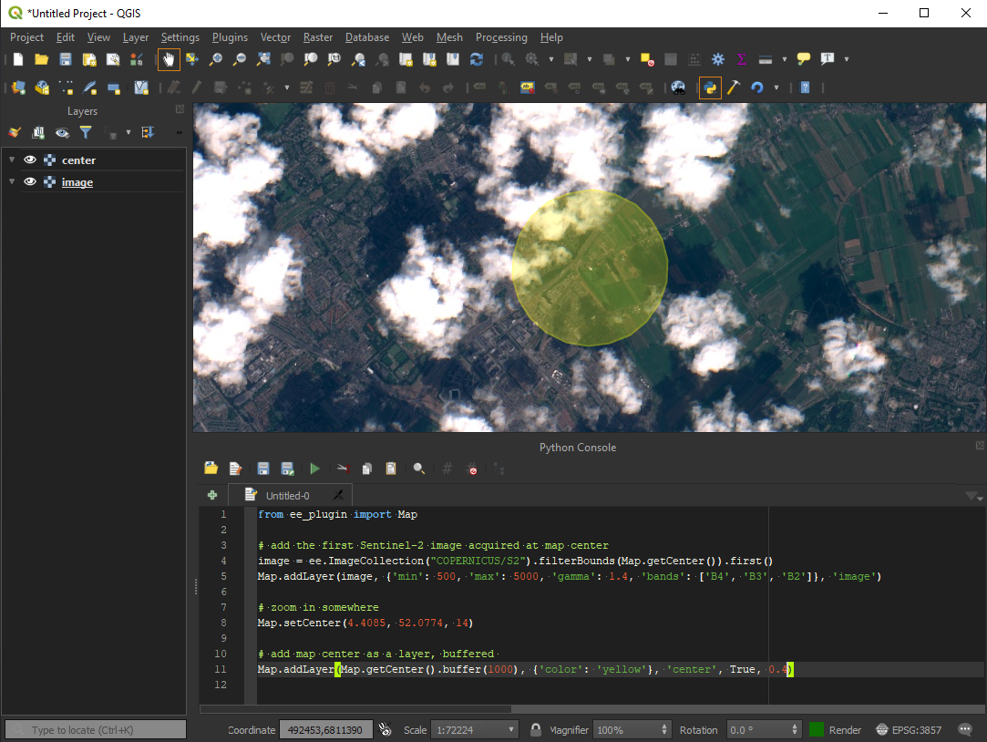
You can use Earth Engine datasets programmatically within QGIS using the `Python Console`:
```python
import ee
from ee_plugin import Map
image = ee.Image('USGS/SRTMGL1_003')
vis_params = {
'min': 0, 'max': 4000,
'palette': ['006633', 'E5FFCC', '662A00', 'D8D8D8', 'F5F5F5']
}
Map.addLayer(image, vis_params, 'Digital Elevation Model')
Map.setCenter(-121.753, 46.855, 9)
```
### Algorithms via Processing Toolbox and Plugin Menu
Earth Engine algorithms are available from:
- The **Processing Toolbox** (`Processing > Toolbox > Google Earth Engine`)
- The **Plugin Menu** (`Plugins > Google Earth Engine`)
See [available algorithms](#-available-algorithms) for more details.

### Model Designer
Earth Engine algorithms can be integrated into QGIS **Model Designer** workflows:
- Open `Processing Toolbox > Models > Create New Model`
- Add and chain EE algorithms with other QGIS algorithms
- Save your custom processing model for repeated use
An [example model](https://github.com/gee-community/qgis-earthengine-plugin/blob/master/examples/srtm_hillshade.model3) is provided for the hillshade example below:

### Saving Your Project
Any layers and model workflows can be saved in your QGIS project file.
Be sure to re-authenticate if opening the project on a new machine or after token expiry.
---
## ⚙️ Available Algorithms
The following algorithms are currently implemented in the plugin:
| Algorithm Name | Description |
| -------------------------- | --------------------------------------------- |
| Add EE Image | Loads a single Earth Engine image for viewing |
| Add Image Collection | Loads a filtered Earth Engine image collection for viewing|
| Export GeoTIFF | Exports an EE image as a Cloud-Optimized GeoTIFF to disk |
| Add Feature Collection | Loads a feature collection from Earth Engine |
📌 Each algorithm includes in-dialog documentation to help guide usage directly within QGIS.
---
## 🗺️ Map Functions
The plugin supports several **Map API functions** similar to the Earth Engine Code Editor:
| Function | Description |
| --------------------------------------------------------- | ----------------------------------- |
| `Map.addLayer(eeObject, visParams, name, shown, opacity)` | Adds a dataset to QGIS. |
| `Map.centerObject(object, zoom)` | Centers the map on an object. |
| `Map.getBounds(asGeoJSON)` | Returns map bounds. |
| `Map.getCenter()` | Gets the current center of the map. |
| `Map.setCenter(lon, lat, zoom)` | Moves the center of the map. |
| `Map.getScale()` | Returns the current map scale. |
| `Map.getZoom()` | Returns the current zoom level. |
| `Map.setZoom(zoom)` | Sets a new zoom level. |
For more details, check the [Earth Engine API Documentation](https://developers.google.com/earth-engine/getstarted#adding-data-to-the-map).
---
## ❓ Troubleshooting
### Resetting Authentication
If you experience authentication issues:
- Run `earthengine authenticate` again.
- Delete the credentials file and restart QGIS:
- **Windows:** `C:\Users\\.config\earthengine\credentials`
- **Linux:** `/home//.config/earthengine/credentials`
- **MacOS:** `/Users//.config/earthengine/credentials`
More on authentication troubleshooting: [Earth Engine Guide](https://developers.google.com/earth-engine/guides/auth).
### Common Errors
| Error | Solution |
| -------------------------------------------------- | --------------------------------------------------------------------------------------------------------------------- |
| `ModuleNotFoundError: No module named 'ee_plugin'` | Ensure the plugin is installed via QGIS Plugin Manager. |
| `earthengine authenticate` fails | Run `earthengine authenticate --quiet` and restart QGIS. |
| `ssl.SSLError: [SSL: CERTIFICATE_VERIFY_FAILED]` | On MacOS, run `/Applications/Python 3.x/Install Certificates.command`. |
| Plugin crashes after authentication | Ensure your IP is not blocked by a firewall. Check [code.earthengine.google.com](http://code.earthengine.google.com). |
| `SRE module mismatch` | Set `PYTHONPATH` to plugin extlibs (e.g. `export PYTHONPATH=~/Projects/qgis-earthengine-plugin/extlibs`) |
---
## 🤝 Contributing
We warmly welcome contributions! If you'd like to contribute:
1. Check out [CONTRIBUTING.md](CONTRIBUTING.md) for setup instructions.
2. Ensure your contribution relates to an existing [issue](https://github.com/gee-community/qgis-earthengine-plugin/issues) or discussion.
3. Open a pull request or issue before starting major changes.
For questions, contact the original author: [gennadiy.donchyts@gmail.com](mailto:gennadiy.donchyts@gmail.com).
For feature requests and updates, please check the [GitHub Issues](https://github.com/gee-community/qgis-earthengine-plugin/issues) and [Discussions](https://github.com/gee-community/qgis-earthengine-plugin/discussions).
Thank you for helping improve the QGIS Earth Engine Plugin!