Ecosyste.ms: Awesome
An open API service indexing awesome lists of open source software.
https://github.com/52north/helgoland-toolbox
Collection of tools for a sensor observation based client
https://github.com/52north/helgoland-toolbox
Last synced: 29 days ago
JSON representation
Collection of tools for a sensor observation based client
- Host: GitHub
- URL: https://github.com/52north/helgoland-toolbox
- Owner: 52North
- License: other
- Created: 2017-10-18T07:00:18.000Z (about 7 years ago)
- Default Branch: develop
- Last Pushed: 2024-05-02T17:18:42.000Z (6 months ago)
- Last Synced: 2024-09-27T18:22:24.944Z (about 1 month ago)
- Language: TypeScript
- Homepage: https://52north.github.io/helgoland-toolbox/
- Size: 28.8 MB
- Stars: 13
- Watchers: 9
- Forks: 16
- Open Issues: 16
-
Metadata Files:
- Readme: README.md
- License: LICENSE
Awesome Lists containing this project
README
# helgoland-toolbox
> tools for a sensor observation service based client
[](https://badge.fury.io/js/%40helgoland%2Fcore)
This project contains [Angular](https://angular.io/) based Modules, Components, Injectables to build a sensor observation service based client.
## Description
### Tools for Building Web Applications
**Providing Reusable Components for Building (Sensor Web) Client Applications**
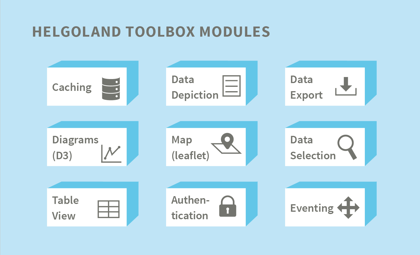
52°North created the Helgoland Toolbox to facilitate the reuse of developments for Sensor Web client applications. It provides a range of modules that offer functionalities for building Web applications dealing with dynamic spatio-temporal data. The Helgoland Toolbox modules are used to build the 52°North Helgoland Sensor Web Viewer. Additional applications (e.g. the BelAir app, smle, or the developments resulting from the TaMIS project) are also built upon this library.
**Features:**
The most important functional modules comprise:
Core
- Communication with the APIs (Helgoland API and OGC SensorThings API)
- Important common services (local storage, time)
- Central interfaces and abstract classes
Caching
- Request Caching with Angular Interceptors
d3
- Trajectory Graph component
- Time Series Graph component
Depiction
- Legend entries
- Table view of data
Map
- Controls (Geo-Search, Locate, Zoom, Extent)
- Map Selector component
Selectors
- List Selector for observation data
- Service Selector for data sources.
The work on the Helgoland Toolbox focused on improving Helgoland Toolbox’s support of the OGC SensorThings API standard. A dedicated layer to improve the abstraction of underlying data sources enables the Helgoland Sensor Web Viewer to consume data directly from OGC compliant SensorThings API instances as well as connect to the 52°North Helgoland API.
Research covered experimenting on how to achieve the integration of access-controlled data sources and incorporation of near-real time data streams via MQTT. For this purpose, we developed a dedicated dashboard for visualizing research vessel tracking data based on our toolbox. This development was part of the EMODnet Ingestion 2 project.
**Key Technologies:**
- [JavaScript](https://www.javascript.com/)
- [TypeScript](https://www.typescriptlang.org/)
- [Angular](https://angular.io/)
- [Leaflet](https://leafletjs.com/)
- [d3](https://d3js.org/)
- Open Layers
**Benefits:**
- Reusable components for building client applications
- Modules for visualizing different types of sensor data (time series, trajectories, profiles)
- Mapping modules
- Different components for data selection
## Quick Start
### Dependencies
#### Node/NPM
Install latest Node and NPM following the [instructions](https://nodejs.org/en/download/). Make sure you have Node version ≥ 10 and NPM ≥ 6. `brew install node` for Mac.
### Installing
- `fork` this repository.
- `clone` your fork to your local environment.
- `npm install` to install required dependencies.
### Build the libraries
- `npm run lib:build` for building the library once
### Other commands
#### Lint the complete code
- `npm start` will start the test application, which provide views for the main modules and components
- the app, and their corrensponding files can be found in the `src` folder
### See Documentation
- a module based documentation can be found here:
- there is also a how to page with different use cases:
## References
The software is in operational use by the following organizations or within the following projects.
- [Federal Maritime and Hydrographic Agency (BSH)](https://www.bsh.de/)
- [Wupperverband](https://www.wupperverband.de/)
- [SeaDataCloud](https://www.seadatanet.org/About-us/SeaDataCloud)
- [WaCoDiS](https://wacodis.fbg-hsbo.de/)
- [MuDak-WRM](https://www.mudak-wrm.kit.edu/)
- [mVIZ](https://mviz.geo.tu-dresden.de/)
- [EMODnet Data Ingestion Portal](https://www.emodnet-ingestion.eu/)
## Development
- different moduls are in the projects folder
### use customized toolbox in an other app development
#### build Toolbox
- `npm run lib:build` builds the complete toolbox in the `dist`-folder
- after build `npm run lib:pack` packs every module to a file in the following structure `helgoland-MODULENAME-CURRENT_VERSION.tgz` in the `root`-folder
- every packed module can be used by installing it in app development with it's relative path, for example `npm install ../helgoland-toolbox/helgoland-MODULENAME-CURRENT_VERSION.tgz`
### Other commands
#### Run tests
- all implemented tests for the modules can be run by `npm test`
#### Lint the complete code
- `ng lint` for performing static code analysis.
#### Generate documentation
- `npm run compodoc` for generating documentation locally
- `npm run gh-pages` for generating documentation and uploading it to GitHub Pages
##### Bump library version
- `npm version ***` to increase library version. [More on bumping](https://docs.npmjs.com/cli/version).
## Troubleshooting while using this library
- add `allowSyntheticDefaultImports: true` to your tsconfig.json to avoid error messages like `... has no default export`
- don't forget to add styles of nested dependencies
## Funding organizations/projects
The development of this client implementations was supported by several organizations and projects. Among other we would like to thank the following organisations and projects:
| Project/Logo | Description |
| :-------------: | :------------- |
| 
 | The development of this version of the 52°North SOS was supported by the German Federal Ministry of Education and Research research project TaMIS (co-funded by the German Federal Ministry of Education and Research, programme Geotechnologien, under grant agreement no. 03G0854[A-D]) |
|  | The development of this version of the 52°North SOS was supported by the European Union’s Horizon 2020 research project JERICO-S3 (co-funded by the European Commission under the grant agreement n°871153) |
|  | The development of this version of the 52°North SOS was supported by the European FP7 research project NeXOS (co-funded by the European Commission under the grant agreement n°614102) |
| 
 | The development of this version of the 52°North SOS was supported by the German Federal Ministry of Education and Research research project COLABIS (co-funded by the German Federal Ministry of Education and Research, programme Geotechnologien, under grant agreement no. 03G0852A) |
| 
 | The development of this version of the 52°North SOS was supported by the German Federal Ministry of of Transport and Digital Infrastructure research project WaCoDis (co-funded by the German Federal Ministry of Transport and Digital Infrastructure, programme mFund) |
| 

 | The development of this version of the 52°North SOS was supported by the German Federal Ministry of Education and Research research project MuDak-WRM (co-funded by the German Federal Ministry of Education and Research, programme FONA) |
|  | The development of this version of the 52°North SOS was supported by the Horizon 2020 research project SeaDataCloud (co-funded by the European Commission under the grant agreement n°730960) |
|  | The development of this version of the 52°North SOS was supported by the Horizon 2020 research project ODIP II (co-funded by the European Commission under the grant agreement n°654310) |
|  | The Wupperverband for water, humans and the environment (Germany) |
|  | The Belgian Interregional Environment Agency (IRCEL - CELINE) is active in the domain of air quality (modelling, forecasts, informing the public on the state of their air quality, e-reporting to the EU under the air quality directives, participating in scientific research on air quality, etc.). IRCEL — CELINE is a permanent cooperation between three regional environment agencies: Agence wallonne de l'Air et du Climat (AWAC), Bruxelles Environnement - Leefmilieu Brussel and Vlaamse Milieumaatschappij (VMM). |