https://github.com/MohanadDiab/langrs
https://github.com/MohanadDiab/langrs
Last synced: 5 months ago
JSON representation
- Host: GitHub
- URL: https://github.com/MohanadDiab/langrs
- Owner: MohanadDiab
- License: mit
- Created: 2024-06-04T11:34:26.000Z (about 1 year ago)
- Default Branch: main
- Last Pushed: 2025-02-10T16:33:55.000Z (5 months ago)
- Last Synced: 2025-02-10T17:35:45.637Z (5 months ago)
- Language: Python
- Size: 34.8 MB
- Stars: 2
- Watchers: 1
- Forks: 1
- Open Issues: 0
-
Metadata Files:
- Readme: README.md
- License: LICENSE
Awesome Lists containing this project
- Awesome-Segment-Anything - [code
README
# LangRS
[](https://colab.research.google.com/github/MohanadDiab/langrs/blob/main/examples/langrs.ipynb)
[](https://pypi.python.org/pypi/langrs)

**A python package that omptimizes zero-shot segmentation of aerial image based with GroundingDINO and Segment Anything Model (SAM)**
# Introduction
LangRS is a Python package for remote sensing image segmentation, it is built on top of the [Segment-Geospatial](https://github.com/opengeos/segment-geospatial) package. It combines advanced techniques like bounding box detection, semantic segmentation, and outlier rejection to deliver precise and reliable segmentation of geospatial images.
## Citation
TBD
## Features
- **Bounding Box Detection:** Locate objects in remote sensing images with a sliding window approach.
- **Outlier Detection:** Apply various statistical and machine learning methods to filter out anomalies in the detected objects based on the area of the detected bounding boxes.
- **Area Calculation:** Compute and rank bounding boxes by their areas.
- **Image Segmentation:** Detect and extract objects based on text prompts using LangSAM.
---
## Installation
### Install LangRS with pip
```bash
pip install langrs
```
### Direct install
Ensure you have Python 3.10 or higher installed. Install the required dependencies.
Clone the repository and install the package locally:
```bash
git clone https://github.com/MohanadDiab/langrs.git
cd langrs
pip install .
```
---
## Usage
Here is an example of how to use the `LangRS` class for remote sensing image segmentation:
```python
from langrs.core import LangRS
def main():
# Specify a text prompt to identify objects in the image
text_input = "object"
# Path to the input remote sensing image
image_input = "path_to_your_tif_file"
# Initialize LangRS with the input image, text prompt, and output directory
langrs = LangRS(image_input, text_input, "output_folder")
# Detect bounding boxes using the sliding window approach with example parameters
bounding_boxes = langrs.predict_dino(window_size=600, overlap=300, box_threshold=0.25, text_threshold=0.25)
# Apply outlier rejection to filter anomalous bounding boxes
# This will return a dict with the follwing keys:
# ['zscore', 'iqr', 'svm', 'svm_sgd', 'robust_covariance', 'lof', 'isolation_forest']
# The value of each key represent the boudning boxes from the previous step with the
# outlier rejection method of the key's name applied to them
bboxes_filtered = langrs.outlier_rejection()
# Generate segmentation masks for the filtered bounding boxes of the provided key
masks = langrs.predict_sam(rejection_method="zscore")
# Or
masks = langrs.predict_sam(rejection_method="iqr")
if __name__ == "__main__":
main()
```
### Input Parameters for LangRS Methods
#### `LangRS` Initialization:
- `image`: Path to the input image.
- `prompt`: Text prompt for object detection.
- `output_path`: Directory to save output files.
#### `predict_dino`:
- `window_size` (int): Size of each chunk for processing. Default is `500`.
- `overlap` (int): Overlap size between chunks. Default is `200`.
- `box_threshold` (float): Confidence threshold for box detection. Default is `0.5`.
- `text_threshold` (float): Confidence threshold for text detection. Default is `0.5`.
#### `outlier_rejection`:
Applies multiple outlier detection methods (e.g., Z-Score, IQR, SVM, LOF) to filter bounding boxes.
#### `predict_sam`:
- `rejection_method` (str): The method used for filtering outliers. Options include `zscore`, `iqr`, `svm`, `lof`, etc.
---
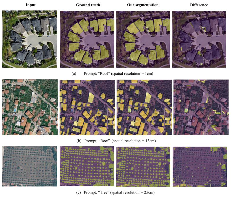
## Example segmentation
## 📊 Package Performance vs Ground Truth
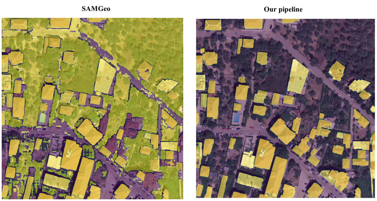
## 🔄 Direct Comparison with SAMGEO Package
## Output
When the code runs, it generates the following outputs:
1. **Original Image with Bounding Boxes:** Shows the detected bounding boxes.
2. **Filtered Bounding Boxes:** Bounding boxes after applying outlier rejection.
3. **Segmentation Masks:** Overlays segmentation masks on the original image.
4. **Area Plot:** A scatter plot of bounding box areas to visualize distributions.
The results are saved in the specified `output` directory, organized with a timestamp to separate runs.
---
## Contributing
We welcome contributions! If you'd like to add features or fix bugs:
1. Fork the repository.
2. Create a feature branch.
3. Submit a pull request.
---
## License
This project is licensed under the MIT License. See the [LICENSE](LICENSE) file for details.
---
## Support
For any questions or issues, please open an issue on GitHub or contact the project maintainers.