https://github.com/Napattnpp/DIMZ
The Intelligent Disaster Management System with Alternative Energy and AI-Powered
https://github.com/Napattnpp/DIMZ
ai arduino-ide environment image-encryption image-transfer python3 raspberry-pi-pico raspberrypi
Last synced: 8 months ago
JSON representation
The Intelligent Disaster Management System with Alternative Energy and AI-Powered
- Host: GitHub
- URL: https://github.com/Napattnpp/DIMZ
- Owner: Napattnpp
- Created: 2024-06-17T13:31:25.000Z (about 2 years ago)
- Default Branch: main
- Last Pushed: 2025-01-21T16:18:24.000Z (over 1 year ago)
- Last Synced: 2025-01-21T17:27:53.588Z (over 1 year ago)
- Topics: ai, arduino-ide, environment, image-encryption, image-transfer, python3, raspberry-pi-pico, raspberrypi
- Language: C++
- Homepage: https://dev.to/napattnpp/the-intelligent-disaster-management-system-with-alternative-energy-and-ai-powered-5gkc
- Size: 3.04 MB
- Stars: 0
- Watchers: 1
- Forks: 0
- Open Issues: 0
-
Metadata Files:
- Readme: README.md
Awesome Lists containing this project
README
# The Intelligent Disaster Management System with Alternative Energy and AI-Powered (Earlier version of the document)
### Objective
The objective of our project is to transition from a human-based observation to a camera-based system. Cameras have a much longer viewing distance than humans, and our system provides notifications much faster than manual methods, helping to avoid danger more effectively.

---
### How Does It Work?
Our project has three main components:
1. **Wildfire Detection Pole**: This pole is set up in the forest to detect fires.
2. **Data Center**: It receives information from the Wildfire Detection Pole and sends it to the internet, allowing users to monitor the temperature and other data around the pole.
3. **Application**: A mobile app that provides essential wildfire-related features and notifications.
---
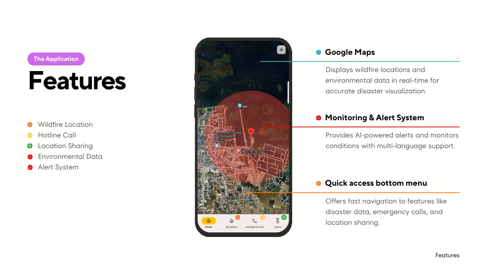
### Application Features
Our application includes five key features:
1. **Wildfire Location**
- The app displays the locations of active wildfires. For example, if there are wildfires in three places, it lists those locations for easy reference.
2. **Hotline Call**
- Users can directly call emergency hotlines from within the app.
3. **Location Sharing**
- Users can share their current location with others. For instance, someone in the forest during a wildfire can send their location to request help.
4. **Environmental Data**
- The app provides real-time data, including temperature, humidity, and gas levels around the pole.
5. **Alert System**
- If a wildfire is detected, a red circle appears on the map to indicate the affected area. Users within this red circle receive a notification sound, prompting them to evacuate the danger zone.
---
### The Wildfire Detection Pole
The Wildfire Detection Pole integrates the following components:
- **Raspberry Pi Pico Board**: Handles environmental sensors and initial data processing.
- **Raspberry Pi 5 Board**: Controls the camera and processes image data for object detection.
- **Camera System**: Rotates back and forth to scan the environment and detect wildfires.
#### How It Works
1. The Raspberry Pi 5 connects to the Raspberry Pi Pico and the camera, controlling the camera's rotation.
2. The camera uses an object detection system to identify wildfires. When a wildfire is detected:
- The camera stops rotating and captures images of the wildfire.
- These images and temperature and humidity data are sent to the Data Center.
3. If no wildfires are detected:
- The camera continues rotating and pauses for 30 seconds after completing a full rotation.
- Temperature and humidity data are sent every 30 minutes.