https://github.com/andreaswbartels/jgisshell
Java GIS Viewer and Layer Datastore Manager
https://github.com/andreaswbartels/jgisshell
arcgis-rest-api ckan geojson geopackage georss gis groovy-scripts h2-database hana mapbox oracle postgis shapefile spatial-data spatialite sql-client sqlserver wfs wms wmts
Last synced: about 1 year ago
JSON representation
Java GIS Viewer and Layer Datastore Manager
- Host: GitHub
- URL: https://github.com/andreaswbartels/jgisshell
- Owner: AndreasWBartels
- License: other
- Created: 2016-08-19T16:08:11.000Z (almost 10 years ago)
- Default Branch: master
- Last Pushed: 2022-01-12T11:58:49.000Z (over 4 years ago)
- Last Synced: 2025-07-05T00:03:57.777Z (about 1 year ago)
- Topics: arcgis-rest-api, ckan, geojson, geopackage, georss, gis, groovy-scripts, h2-database, hana, mapbox, oracle, postgis, shapefile, spatial-data, spatialite, sql-client, sqlserver, wfs, wms, wmts
- Language: Groovy
- Homepage:
- Size: 650 MB
- Stars: 7
- Watchers: 2
- Forks: 2
- Open Issues: 0
-
Metadata Files:
- Readme: README.md
- License: license.txt
Awesome Lists containing this project
README
# JGISShell
see [DOAG Geodata Days 2017 slides](https://github.com/AndreasWBartels/JGISShell/wiki/Presentations)
---
## Java GIS Viewer and Spatial Layer Datastore Manager
JGSShell is a Java based spatial data viewer and layer datastore manager. It consist of 4 parts, a viewer, a spatial-layer manager, a scripting API (groovy and Java) and a URL concept.
JGISShell was created 10 years ago as a private education and evaluation project to explore spatial data and technologies. Now it riched a state that it could be usefull for other. Maybe to learn, explore spatial data or manage spatial data.
## Geodata Viewer
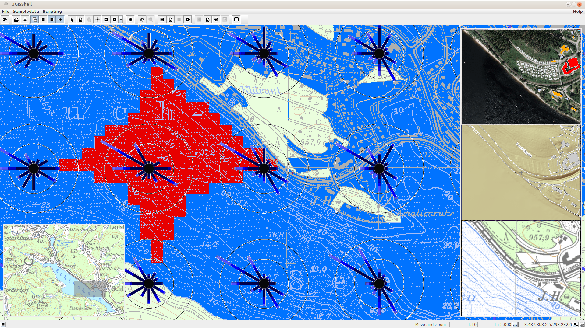
`map source: © 2016 Landesanstalt für Umwelt, Messungen und Naturschutz Baden-Württemberg and Landesamt für Geoinformation und Landentwicklung Baden-Württemberg`
[further screenshots](https://github.com/AndreasWBartels/JGISShell/tree/master/doc/manual/images)
The viewer supports the following formats:
### Feature based geodata
WFS, Shapefiles, GeoJSON, PostGIS, SpatiaLite, GeoPackage, H2 Database. Oracle Locator/Spatial, MSSQL/SQLServer, SAP Hana, ESRI MDB based Geodatabases, ESRI Arc GIS Rest Feature Services and a own GML equal XML format.
### Image based geodata
WMS, WMTS, PostGIS Raster, Worldfiles, mbtiles, OSM, MAPBOX Tile Layers, GeoPackage, ESRI Arc GIS Rest Map and Image Services
### Grid based geodata
ESRI ASCII Grid, Saga Grid and XYZ Grid files
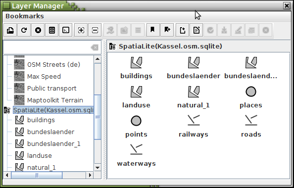
## Layer Manager
The manager is like a spatial data file system manager for exploring and managing geospatial data.
## Scripting
The scripting API can be used to extend the Viewer and the Manager or to process geospatial data.
```groovy
import net.anwiba.scripting.groovy.JGISShellGroovyScript
@groovy.transform.BaseScript JGISShellGroovyScript facade
map().
add("Bundesl\u00e4nder",
layerReference(
"\$SYSTEM{jgisshell.workingpath}/data/bundeslaender.shp"
)
);
```
## Data access URL schema
The URL based schema is designed to access different kinds of datastores or spatial layers.
## Open Data search
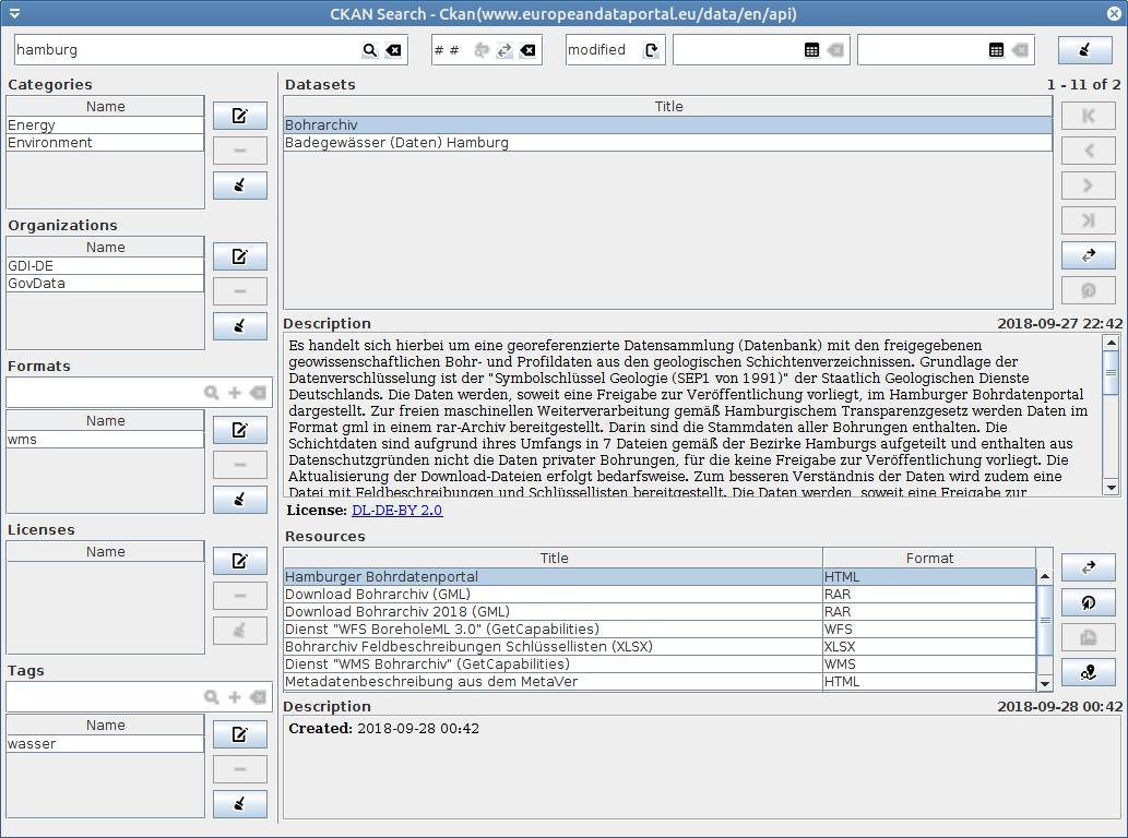
`ckan search dialog using european data portal https://www.europeandataportal.eu/`
## Author
JGISShell was created by [Andreas W. Bartels](https://github.com/AndreasWBartels).
## License
JGISShell (JGISShell.jar) has a reduced [BSD](https://www.freebsd.org/copyright/freebsd-license.html) license. Which regulates the use of the binary code.
See [license.txt](https://github.com/AndreasWBartels/JGISShell/blob/master/license.txt) for more information.
The source-code, insofar as it is published, is located in this project [libraries](https://github.com/AndreasWBartels/libraries) and has the LGPL V2.1 license.
The source code published in this project, in the scripts folder, has the GPL V3 license.
## Installation
see [WIKI - JGISShell-Installation](https://github.com/AndreasWBartels/JGISShell/wiki/JGISShell-Installation)
For more download this project and open doc/manual/index.html.