https://github.com/atsyplenkov/wbw
Whitebox Workflows for R
https://github.com/atsyplenkov/wbw
Last synced: about 1 year ago
JSON representation
Whitebox Workflows for R
- Host: GitHub
- URL: https://github.com/atsyplenkov/wbw
- Owner: atsyplenkov
- License: other
- Created: 2024-12-24T03:04:04.000Z (over 1 year ago)
- Default Branch: main
- Last Pushed: 2025-01-14T05:07:58.000Z (over 1 year ago)
- Last Synced: 2025-04-21T08:13:00.790Z (about 1 year ago)
- Language: R
- Homepage: https://wbw.anatolii.nz
- Size: 10.3 MB
- Stars: 31
- Watchers: 1
- Forks: 3
- Open Issues: 3
-
Metadata Files:
- Readme: README.md
- Changelog: NEWS.md
- Contributing: CONTRIBUTING.md
- License: LICENSE
Awesome Lists containing this project
README
# Whitebox Workflows for R `{wbw}` 
[](https://www.repostatus.org/#wip)
[](https://github.com/atsyplenkov/wbw/issues/1)
[](https://github.com/atsyplenkov/wbw/actions/workflows/R-CMD-check.yaml)
[](https://app.codecov.io/gh/atsyplenkov/wbw)

---
---
> [!NOTE]
> `{wbw}` is currently in alpha. Expect breaking changes both in the API and in outputs.
The `{wbw}` package provides R bindings for the [Whitebox Workflows for Python](https://www.whiteboxgeo.com/whitebox-workflows-for-python/) — a powerful and fast library for advanced geoprocessing, with focus on hydrological, geomorphometric and remote sensing analysis of raster, vector and LiDAR data.
## Basic workflow
The `{wbw}` R package introduces several new S7 classes, including
`WhiteboxRaster` and `WhiteboxVector` which serves as a bridge between
Python and R.
``` r
library(wbw)
raster_path <- system.file("extdata/dem.tif", package = "wbw")
dem <- wbw_read_raster(raster_path)
dem
#> +------------------------------------------+
#> | WhiteboxRaster |
#> | dem.tif |
#> |..........................................|
#> | bands : 1 |
#> | dimensions : 726, 800 (nrow, ncol) |
#> | resolution : 5.002392, 5.000243 (x, y) |
#> | EPSG : 2193 (Linear_Meter) |
#> | min value : 63.698193 |
#> | max value : 361.020721 |
#> +------------------------------------------+
```
The true power of `{wbw}` unleashes when there’s a need to run several
operations sequentially, i.e., in a pipeline. Unlike the original
Whitebox Tools, WbW [stores files in
memory](https://www.whiteboxgeo.com/manual/wbw-user-manual/book/introduction.html#how-does-wbw-compare-with-related-whitebox-products),
reducing the amount of intermediate I/O operations.
For example, a DEM can be smoothed (or filtered), and then the slope can
be estimated as follows:
``` r
dem |>
wbw_mean_filter() |>
wbw_slope(units = "d")
#> +------------------------------------------+
#> | WhiteboxRaster |
#> | Slope (degrees) |
#> |..........................................|
#> | bands : 1 |
#> | dimensions : 726, 800 (nrow, ncol) |
#> | resolution : 5.002392, 5.000243 (x, y) |
#> | EPSG : 2193 (Linear_Meter) |
#> | min value : 0.005972 |
#> | max value : 50.069439 |
#> +------------------------------------------+
```
## Yet Another RSpatial Package? Why?
The above example may remind you of the `{terra}` package, and it is not
a coincidence. The `{wbw}` package is designed to be fully compatible
with `{terra}`, and the conversion between `WhiteboxRaster` and
`SpatRaster` objects happens in milliseconds (well, depending on the
raster size, of course).
``` r
library(terra)
wbw_read_raster(raster_path) |>
wbw_gaussian_filter(sigma = 1.5) |>
wbw_aspect() |>
as_rast() |> # Conversion to SpatRaster
plot(main = "Aspect")
```

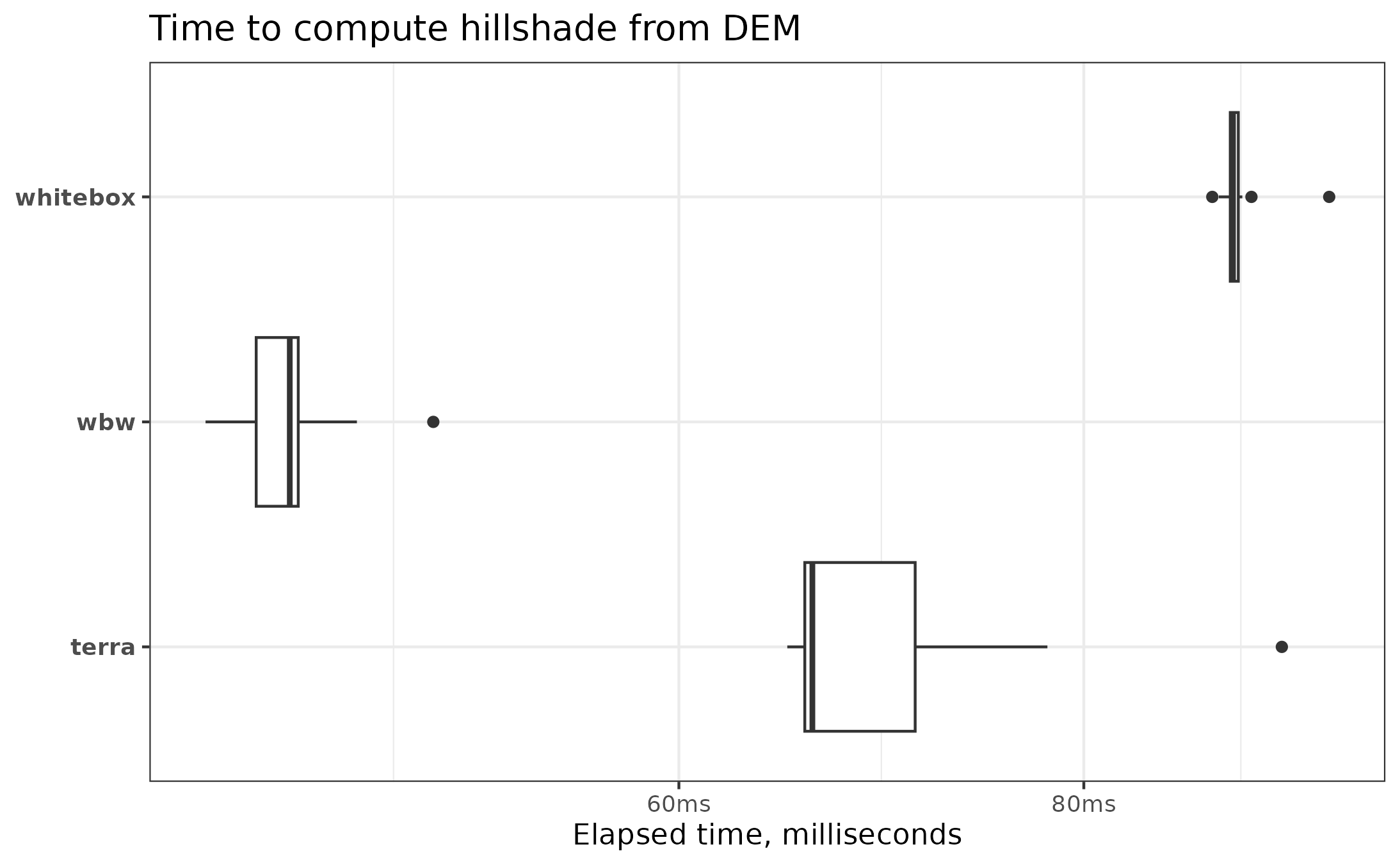
The `{wbw}` package is quite fast; you can see the detailed benchmarks [here](https://wbw.anatolii.nz/articles/benchmarks.html). In most cases, it is as fast as `terra`, while excelling in some more complex tasks (such as hillshading and filtering). Additionally, `wbw` outperforms the original `{whitebox}` by 2 to 3 times, as the amount of I/O operations is reduced to a minimum.
## Installation
You can install the development version of `{wbw}` from
[GitHub](https://github.com/) with:
``` r
# install.packages("pak")
pak::pak("atsyplenkov/wbw")
```
> [!TIP]
> The `{wbw}` package requires the `whitebox-workflows` Python library
> v1.3.3+. However, you should not worry about it, as the package
> is designed to install all dependencies automatically on the first run.
Your machine should have **Python 3.8+** installed with `pip` and `venv` configured. Usually, these requirements are met on all modern computers. However, clean Debian installs may require the installation of system dependencies:
```bash
apt update
apt install python3 python3-pip python3-venv -y
```
## Contributing
Contributions are welcome! Please see our [contributing
guidelines](CONTRIBUTING.md) for details. There is an open issue for the
`{wbw}` package [here](https://github.com/atsyplenkov/wbw/issues/1) that
contains a list of functions yet to be implemented. This is a good place
to start.
## See also
Geomorphometric and hydrological analysis in R can be also done with:
- [`{whitebox}`](https://github.com/opengeos/whiteboxR) — An R frontend for the [WhiteboxTools](https://www.whiteboxgeo.com) standalone runner.
- [`{traudem}`](https://github.com/lucarraro/traudem/) — R bindings to [TauDEM](https://hydrology.usu.edu/taudem/taudem5/) (Terrain Analysis Using Digital Elevation Models) command-line interface.
- [`{RSagacmd}`](https://github.com/stevenpawley/Rsagacmd/) and [`{RSAGA}`](https://github.com/r-spatial/RSAGA) — Links R with [SAGA GIS](https://sourceforge.net/projects/saga-gis/).
- [`{rivnet}`](https://github.com/lucarraro/rivnet) — river network extraction from DEM using TauDEM.