https://github.com/hyriver/seamless-3dep
Topographic map retrieval from 3DEP
https://github.com/hyriver/seamless-3dep
elevation hydrology python topographic-maps
Last synced: 10 months ago
JSON representation
Topographic map retrieval from 3DEP
- Host: GitHub
- URL: https://github.com/hyriver/seamless-3dep
- Owner: hyriver
- License: mit
- Created: 2024-12-22T20:55:08.000Z (over 1 year ago)
- Default Branch: main
- Last Pushed: 2025-09-01T14:43:26.000Z (11 months ago)
- Last Synced: 2025-09-25T10:58:42.250Z (10 months ago)
- Topics: elevation, hydrology, python, topographic-maps
- Language: Python
- Homepage: https://seamless-3dep.readthedocs.io
- Size: 24 MB
- Stars: 13
- Watchers: 2
- Forks: 1
- Open Issues: 0
-
Metadata Files:
- Readme: README.md
- Changelog: CHANGELOG.md
- Contributing: CONTRIBUTING.md
- License: LICENSE
- Code of conduct: CODE_OF_CONDUCT.md
- Authors: AUTHORS.md
Awesome Lists containing this project
README
# Seamless3DEP: Streamlined Access to USGS 3DEP Topographic Data
[](https://pypi.python.org/pypi/seamless-3dep)
[](https://anaconda.org/conda-forge/seamless-3dep)
[](https://codecov.io/gh/hyriver/seamless-3dep)
[](https://pypi.python.org/pypi/seamless-3dep)
[](https://pepy.tech/project/seamless-3dep)
[](https://www.codefactor.io/repository/github/hyriver/seamless-3dep)
[](https://github.com/astral-sh/ruff)
[](https://github.com/pre-commit/pre-commit)
[](https://mybinder.org/v2/gh/hyriver/seamless-3dep/HEAD?labpath=docs%2Fexamples)
Seamless3DEP is a lightweight Python package that simplifies access to topographic data
from the USGS
[3D Elevation Program (3DEP)](https://www.usgs.gov/core-science-systems/ngp/3dep).
Whether you need elevation data or its derivatives, Seamless3DEP provides an efficient
interface to both static and dynamic 3DEP products.
Seamless3DEP utilizes connection pooling across threads (safely) to optimize service
calls and minimize redundant connections. This reduces both the service load and the
time required to retrieve data, making it an ideal tool for handling large-scale
topographic data requests.
📚 Full documentation is available [here](https://seamless-3dep.readthedocs.io).
## Available Products
### Static DEMs
- 1/3 arc-second (10 meters)
- 1 arc-second (30 meters)
- 2 arc-second (60 meters)
### Dynamic Products
- Digital Elevation Model (DEM)
- Hillshade Derivatives:
- Gray Hillshade
- Multidirectional Hillshade
- GreyHillshade with Elevation Fill
- Hillshade with Elevation Tint
- Terrain Analysis:
- Aspect (Degrees and Map)
- Slope (Degrees and Map)
- Height (Ellipsoidal)
- Contours:
- Contour 25 (Dynamically generates 25 contours for the area of interest)
- Contour Smoothed 25 (Smoothed version of the 25 contours)
## Core Functions
Seamless3DEP offers four main functions designed for efficient data retrieval and
processing:
- `get_dem`: Retrieves static DEMs within a specified bounding box. The function
automatically splits large areas into manageable tiles, downloads data as GeoTIFF
files in EPSG:4326, and supports resolutions of 10m, 30m, or 60m.
- `get_map`: Fetches any 3DEP product (including DEMs) with customizable parameters.
Works with all available product types, allows custom resolution settings, and
downloads in EPSG:3857. Due to service limitations, the output projection is not
configurable.
- `decompose_bbox`: Handles large area requests by breaking down extensive bounding
boxes into optimal sizes based on resolution and maximum pixel count, ensuring
efficient data retrieval.
- `build_vrt`: Creates virtual raster datasets by combining multiple GeoTIFF files.
Requires `libgdal-core` installation and supports efficient data handling for large
areas. Note that `libgdal-core` is an optional dependency and is not installed when
`seamless-3dep` is installed from PyPI. However, it is installed as a dependency
when `seamless-3dep` is installed from `conda-forge`.
- `tiffs_to_da`: Converts a list of GeoTIFF files to an `xarray.DataArray` object. This
function is useful for combining multiple GeoTIFF files that `get_map` and `get_dem`
produce into a single `xarray.DataArray` object for further analysis. Note that for
using this function, `shapely` and `rioxarray` need to be installed.
## Important Notes
- Bounding box coordinates should be in decimal degrees (WGS84) format: (west, south,
east, north)
- Default projection for requesting maps is EPSG:3857
- EPSG:4326 output projection is not supported in `get_map` due to service limitations
## Installation
Choose your preferred installation method:
### Using `pip`
```console
pip install seamless-3dep
```
### Using `micromamba` (recommended)
```console
micromamba install -c conda-forge seamless-3dep
```
Alternatively, you can use `conda` or `mamba`.
## Quick Start Guide
We can retrieve topographic data using Seamless3DEP in just a few lines of code. Then,
we can visualize or even reproject the data using `rioxarray`.
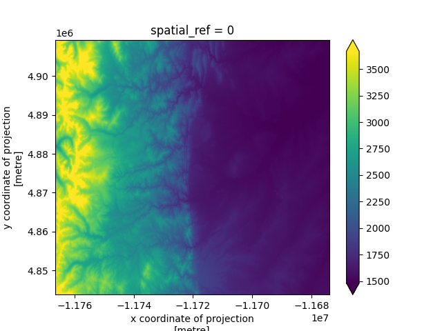
### Retrieving a DEM
```python
from pathlib import Path
import seamless_3dep as s3dep
import rioxarray as rxr
# Define area of interest (west, south, east, north)
bbox = (-105.7006276, 39.8472777, -104.869054, 40.298293)
data_dir = Path("data")
# Download DEM
tiff_files = s3dep.get_dem(bbox, data_dir)
# Convert to xarray.DataArray
dem = s3dep.tiffs_to_da(tiff_files, bbox, crs=4326)
```
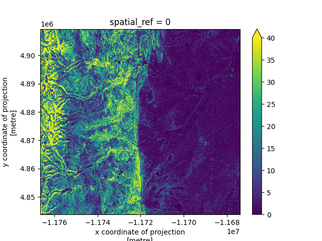
### Retrieving a Slope Map
```python
slope_files = s3dep.get_map("Slope Degrees", bbox, data_dir)
dem = s3dep.tiffs_to_da(slope_files, bbox)
```
## Contributing
We welcome contributions! Please see the
[contributing](https://seamless-3dep.readthedocs.io/en/latest/CONTRIBUTING/) section for
guidelines and instructions.