https://github.com/iliatimofeev/gpdvega
gpdvega is a bridge between GeoPandas and Altair that allows to seamlessly chart geospatial data
https://github.com/iliatimofeev/gpdvega
altair geopandas
Last synced: 5 months ago
JSON representation
gpdvega is a bridge between GeoPandas and Altair that allows to seamlessly chart geospatial data
- Host: GitHub
- URL: https://github.com/iliatimofeev/gpdvega
- Owner: iliatimofeev
- License: bsd-3-clause
- Created: 2018-07-23T17:23:00.000Z (over 7 years ago)
- Default Branch: master
- Last Pushed: 2020-06-24T15:00:46.000Z (over 5 years ago)
- Last Synced: 2024-09-18T03:02:19.664Z (about 1 year ago)
- Topics: altair, geopandas
- Language: Python
- Homepage: https://iliatimofeev.github.io/gpdvega/
- Size: 5.67 MB
- Stars: 52
- Watchers: 4
- Forks: 5
- Open Issues: 5
-
Metadata Files:
- Readme: README.md
- License: LICENSE
Awesome Lists containing this project
- Awesome-Geospatial - gpdvega - gpdvega is a bridge between GeoPandas and Altair that allows to seamlessly chart geospatial data. (Python)
- awesome-gis - gpdvega - gpdvega is a bridge between GeoPandas and Altair that allows to seamlessly chart geospatial data. (Geospatial Library / Python)
README
# gpdvega [](https://coveralls.io/github/iliatimofeev/gpdvega?branch=master) [](https://travis-ci.com/iliatimofeev/gpdvega) [](http://hits.dwyl.io/iliatimofeev/gpdvega) [](https://github.com/iliatimofeev/gpdvega/blob/master/LICENSE) [](https://github.com/iliatimofeev/gpdvega/issues)
`gpdvega` is a bridge between [`GeoPandas`](http://geopandas.org/) a geospatial extension of [`Pandas`](https://pandas.pydata.org/) and the declarative statistical visualization library [`Altair`](https://altair-viz.github.io/), which allows to seamlessly chart geospatial data using `altair`.
## Example
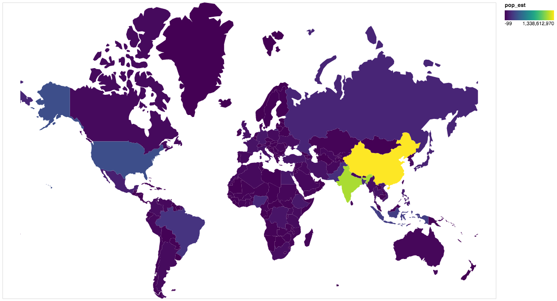
~~~python
import altair as alt
import geopandas as gpd
import gpdvega
alt.renderers.enable('notebook') # render for Jupyter Notebook
world = gpd.read_file(gpd.datasets.get_path('naturalearth_lowres'))
# GeoDataFrame could be passed as usual pd.DataFrame
alt.Chart(world[world.continent!='Antarctica']).mark_geoshape(
).project(
).encode(
color='pop_est', # shorthand infer types as for regular pd.DataFrame
tooltip='id:Q' # GeoDataFrame.index is accessible as id
).properties(
width=500,
height=300
)
~~~
## Install
### Dependencies
gpdvega requires:
- Altair (>= 2.2.0 )
- GeoPandas (>= 0.4.0)
### User installation
using `pip`
pip install gpdvega
### Changelog
See the [changelog]()
for a history of notable changes to gpdvega