https://github.com/jmlich/geotagging
Photography geotagging tool
https://github.com/jmlich/geotagging
exif gps hacktoberfest qt6
Last synced: 4 months ago
JSON representation
Photography geotagging tool
- Host: GitHub
- URL: https://github.com/jmlich/geotagging
- Owner: jmlich
- License: gpl-3.0
- Created: 2016-05-01T06:35:07.000Z (over 9 years ago)
- Default Branch: master
- Last Pushed: 2025-06-17T13:22:10.000Z (7 months ago)
- Last Synced: 2025-07-11T04:41:05.822Z (6 months ago)
- Topics: exif, gps, hacktoberfest, qt6
- Language: C++
- Homepage:
- Size: 8.9 MB
- Stars: 41
- Watchers: 3
- Forks: 8
- Open Issues: 11
-
Metadata Files:
- Readme: README.md
- Changelog: changedatetime.cpp
- Funding: .github/FUNDING.yml
- License: LICENSE
Awesome Lists containing this project
README
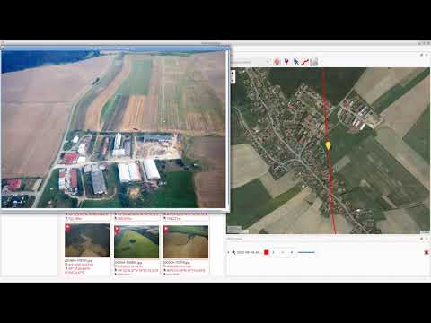
# Introduction

Geotagging is rather simple tool for manipulating with geographical information stored in JPEG images (in EXIF section). Your photos can be augmented by GPS coordinates by synchronization from track log files (*.gpx). The GPS coordinates can be also adjusted manually using Drag and Drop.
# Installation
* Windows - download exe file from [releases section](https://github.com/jmlich/geotagging/releases)
* Fedora - add COPR repository and install rpms
* Other Linux distributions - use flatpak

[](https://copr.fedorainfracloud.org/coprs/jmlich/laa/package/com.github.jmlich.geotagging/)
# Contribute
* Translate to your language at [transifex](https://explore.transifex.com/jozef-mlich/geotagging/).
* Feel free to open issue
* Feel free to create merge request
# Screenshots


# Video tutorial
[](https://www.youtube.com/watch?v=BZhxQC5wgNI)
www.fit.vutbr.cz/study/DP/BP.php.cs?id=11578