https://github.com/krizleebear/osm-polygons
https://github.com/krizleebear/osm-polygons
geojson geojson-data openstreetmap openstreetmap-data reverse-geocoding
Last synced: 4 months ago
JSON representation
- Host: GitHub
- URL: https://github.com/krizleebear/osm-polygons
- Owner: krizleebear
- License: other
- Created: 2019-11-03T10:57:41.000Z (over 6 years ago)
- Default Branch: master
- Last Pushed: 2025-11-23T22:36:26.000Z (7 months ago)
- Last Synced: 2025-11-24T00:18:59.825Z (7 months ago)
- Topics: geojson, geojson-data, openstreetmap, openstreetmap-data, reverse-geocoding
- Language: Java
- Size: 1.32 MB
- Stars: 0
- Watchers: 1
- Forks: 0
- Open Issues: 1
-
Metadata Files:
- Readme: README.md
- License: LICENSE
Awesome Lists containing this project
README
# osm-polygons
## City outline polygons
OpenStreetMap offers geo data in raw data form. For building services you usually have to preprocess the data.
This project takes OSM's raw data, extracts all administrative boundaries and converts them as polygons.
[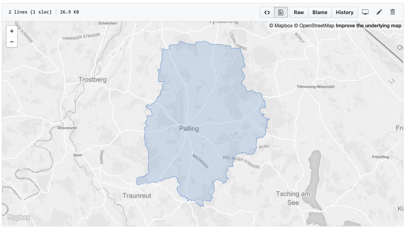 ](../../blob/master/examples/palling.geojson)
## GeoJSON
Here's an example of one of the exported GeoJSON objects:
```
{
"type": "FeatureCollection",
"features": [
{
"type": "Feature",
"properties": {
"name": "Palling",
"boundary": "administrative",
"wikidata": "Q262325",
"wikipedia": "de:Palling",
"admin_level": "8",
"de:regionalschluessel": "091890134134",
"TMC:cid_58:tabcd_1:Class": "Area",
"TMC:cid_58:tabcd_1:LCLversion": "8.00",
"TMC:cid_58:tabcd_1:LocationCode": "4457",
"de:amtlicher_gemeindeschluessel": "09189134"
},
"geometry": {
"type": "Polygon",
"coordinates":[[[12.5950766,47.9703637],[12.5953607,47.9727103],[12.6019791,47.9734364],[12.6054816,47.9756447],[12.6051771,47.9866313],[12.6019101,47.9920364],[12.6015149,48.0000915],[12.6038957,48.0018881],[12.6037128,48.0075969],[12.6080557,48.008038],[12.6067195,48.0110004],[12.6028389,48.0123523],[12.6106511,48.0155409],[12.6186272,48.0264337],[12.6133034,48.0266815],[12.6128961,48.0335542],[12.6155784,48.0330894],[12.6163547,48.0450822],[12.6224712,48.0447456],[12.6224326,48.0468012],[12.6300164,48.0474926],[12.6322431,48.049497],[12.6424822,48.0472457],[12.6451302,48.0475784],[12.6444189,48.0490697],[12.6518457,48.0493225],[12.6564979,48.0476141],[12.6741239,48.0467782],[12.6740106,48.0452744],[12.6816377,48.0458961],[12.6860289,48.0349076],[12.6826671,48.0341289],[12.6856407,48.0294477],[12.6825498,48.0252175],[12.6879822,48.0208599],[12.6911325,48.0219263],[12.6997735,48.0196999],[12.7034477,48.0119514],[12.6993748,48.0120405],[12.6979668,48.0101224],[12.7045551,48.0053099],[12.7061879,48.0062688],[12.7034737,47.9975493],[12.6958825,47.9946762],[12.6934753,47.9865004],[12.6894097,47.9856878],[12.6838769,47.9870427],[12.6761276,47.9840457],[12.6756879,47.979062],[12.6715428,47.9792927],[12.6697612,47.9762248],[12.6723981,47.9721122],[12.6678208,47.9695303],[12.6621719,47.9716884],[12.6592149,47.9703283],[12.6603152,47.9655514],[12.6566373,47.9625804],[12.6586512,47.9613793],[12.6574203,47.9598177],[12.6499559,47.959509],[12.6499691,47.9567339],[12.6433613,47.9602092],[12.6377472,47.9595468],[12.6376127,47.9616367],[12.6321195,47.9624504],[12.6286777,47.9658774],[12.6316785,47.9680828],[12.628837,47.9730173],[12.5969356,47.968864],[12.5950766,47.9703637]]]}
}
]
}
```
## License
This osm-polygons data is made available under the Open Database License: http://opendatacommons.org/licenses/odbl/1.0/. Any rights in individual contents of the database are licensed under the Database Contents License: http://opendatacommons.org/licenses/dbcl/1.0/
## Reverse Geocoding (what's here?)
The polygons offered by this project can e.g. be used to draw the outlines of your city.
Or perform reverse geocoding: Take a point on a map and resolve its administrative membership: City, County, State and City.
My other open source project https://github.com/krizleebear/osm-tools provides tools to do that in Java.
So if you're trying to reverse-geocode huge amounts of data, voilá.
### License considerations
Be aware that you must adhere to ODbL (as stated above) also while reverse geocoding. There's a special guide for that: https://wiki.osmfoundation.org/wiki/Licence/Community_Guidelines/Geocoding_-_Guideline
https://github.com/krizleebear/osm-polygons/releases/tag/v1.0