https://github.com/pantrif/s2-geojson
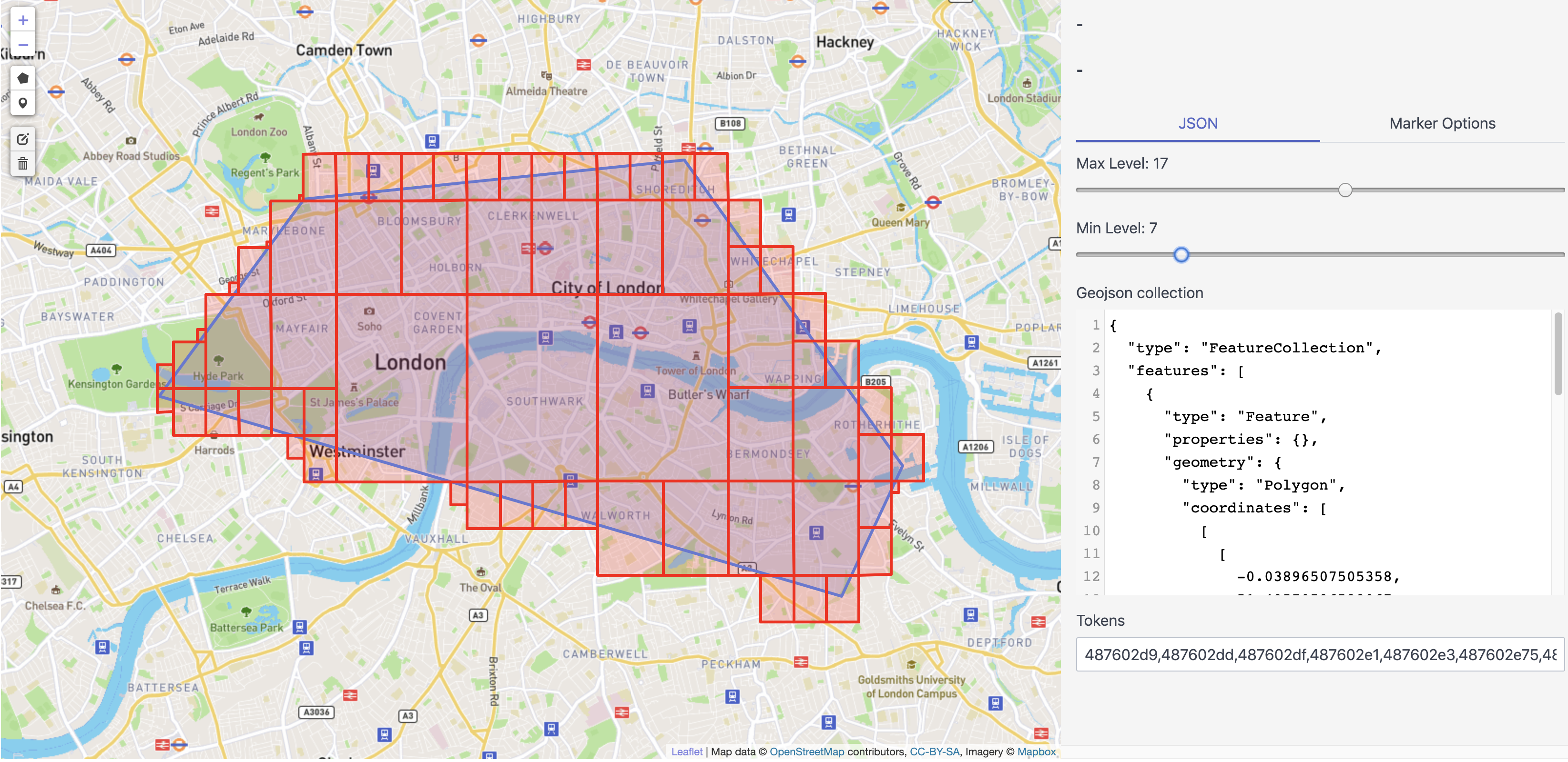
Draw a polygon on the map or paste a geoJSON and explore how the s2.RegionCoverer covers it with S2 cells depending on the min and max levels
https://github.com/pantrif/s2-geojson
geojson go s2
Last synced: over 1 year ago
JSON representation
Draw a polygon on the map or paste a geoJSON and explore how the s2.RegionCoverer covers it with S2 cells depending on the min and max levels
- Host: GitHub
- URL: https://github.com/pantrif/s2-geojson
- Owner: pantrif
- License: mit
- Created: 2020-03-27T09:47:32.000Z (over 6 years ago)
- Default Branch: develop
- Last Pushed: 2024-08-16T05:23:21.000Z (almost 2 years ago)
- Last Synced: 2024-08-16T06:33:48.220Z (almost 2 years ago)
- Topics: geojson, go, s2
- Language: Go
- Homepage:
- Size: 1.69 MB
- Stars: 28
- Watchers: 2
- Forks: 10
- Open Issues: 2
-
Metadata Files:
- Readme: README.md
- License: LICENSE
Awesome Lists containing this project
- fucking-awesome-go - S2 geojson - Convert geojson to s2 cells & demonstrating some S2 geometry features on map. (Geographic / Search and Analytic Databases)
- go-awesome-with-star-updatetime - S2 geojson - Convert geojson to s2 cells & demonstrating some S2 geometry features on map. (Geographic / Advanced Console UIs)
- awesome-go - pantrif/s2-geojson
- awesome-go-extra - s2-geojson - 03-27T09:47:32Z|2020-04-05T06:44:10Z| (Geographic / Advanced Console UIs)
- awesome-go-cn - S2 geojson
- awesome-go - S2 geojson - Convert geojson to s2 cells & demonstrating some S2 geometry features on map. (Geographic / Search and Analytic Databases)
- awesome-go - S2 geojson - Convert geojson to s2 cells & demonstrating some S2 geometry features on map. (Geographic / Search and Analytic Databases)
- awesome-go-cn - S2 geojson - geojson) (地理 / 检索及分析资料库)
- awesome-go-plus - S2 geojson - Convert geojson to s2 cells & demonstrating some S2 geometry features on map.  (Geographic / Search and Analytic Databases)
- awesome-go - S2 geojson - Convert geojson to s2 cells & demonstrating some S2 geometry features on map. (Geographic / Search and Analytic Databases)
- awesome-go-with-stars - S2 geojson - 08-16 | (Geographic / Search and Analytic Databases)
- awesome-go - S2 geojson - Convert geojson to s2 cells & demonstrating some S2 geometry features on map. (Geographic / Search and Analytic Databases)
- awesome-Char - S2 geojson - Convert geojson to s2 cells & demonstrating some S2 geometry features on map. (Geographic / Advanced Console UIs)
- awesome-go-info - s2-geojson
- awesome-go-cn - S2 geojson - geojson) (地理 / 检索及分析资料库)
- awesome-go - S2 geojson - Convert geojson to s2 cells & demonstrating some S2 geometry features on map. (Geographic / Search and Analytic Databases)
README
[](https://travis-ci.com/pantrif/s2-geojson)
[](http://godoc.org/github.com/pantrif/s2-geojson)
[](https://goreportcard.com/report/github.com/pantrif/s2-geojson)
[](https://codecov.io/gh/pantrif/s2-geojson)
## Preview
## Summary
Draw a polygon on the map or paste a geoJSON and explore how the s2.RegionCoverer covers it with S2 cells depending on the min and max levels.
Drop a marker and inspect the corresponding S2 cell.
- Display s2 cells on leaflet map using the region coverer.
- Convert geojson features to cell unions depending on the min and max levels (supported only Polygons and Points).
- Draw points and polygons.
- Check point & circle intersection with the geoJSON features.
## Quick start
```
go run cmd/s2-geojson/main.go
```
## Docker
```
docker run -p 8080:8080 --rm lmaroulis/s2-geojson
```
## License
This project is licensed under the MIT License - see [the LICENSE file](LICENSE) for details.