https://github.com/sofwerx/torgi
Tactical Observation of RF GNSS Interference
https://github.com/sofwerx/torgi
android geo geopackage geospatial gps rf
Last synced: 15 days ago
JSON representation
Tactical Observation of RF GNSS Interference
- Host: GitHub
- URL: https://github.com/sofwerx/torgi
- Owner: sofwerx
- License: apache-2.0
- Created: 2018-08-03T23:07:19.000Z (about 7 years ago)
- Default Branch: master
- Last Pushed: 2020-06-25T20:43:14.000Z (over 5 years ago)
- Last Synced: 2025-04-06T20:36:11.950Z (7 months ago)
- Topics: android, geo, geopackage, geospatial, gps, rf
- Language: HTML
- Homepage:
- Size: 12.7 MB
- Stars: 14
- Watchers: 8
- Forks: 13
- Open Issues: 10
-
Metadata Files:
- Readme: README.md
- License: LICENSE
Awesome Lists containing this project
README
# TORGI
[](https://travis-ci.org/sofwerx/TORGI)
## Tactical Observation of RF GNSS Interference
Collect, store, and display observations and analysis of GPS "fix" availability and quality.
Android 7.0 or higher required; 8.0 recommended. Google Pixel 2 (or Pixel 2 XL) provides Automatic Gain Control data.
#### [Compiled APK (Android app installer)](https://github.com/sofwerx/TORGI/releases/)
GNSS observation points are stored in a [GeoPackage](http://www.geopackage.org/) file with
satellite and receiver clock details using the (proposed)
[Related Tables Extension](https://github.com/opengeospatial/geopackage-related-tables/wiki/Getting-Started) and the [NGA GeoPackage Android SDK](https://ngageoint.github.io/geopackage-android/).
Observation points and associated location fix data are stored as a feature layer within a standard (v1.2) GeoPackage. The Data Model diagram below shows Satellite measurement data and receiver (hardware) clock information tables and their relationships, as currently implemented in the [TORGI app](https://github.com/sofwerx/TORGI/releases/).
The Related Tables Extension is a community standard extension to the GeoPackage map database, moving toward full adoption by [OGC (Open Geospatial Consortium)](http://www.opengeospatial.org/).
## Open Architecture / Open Standards
[
 ](https://portal.opengeospatial.org/public_ogc/compliance/srv_ogc_compliance_badge.php?id=129&pid=1536)
### GeoPackage / SQLite Database ERD
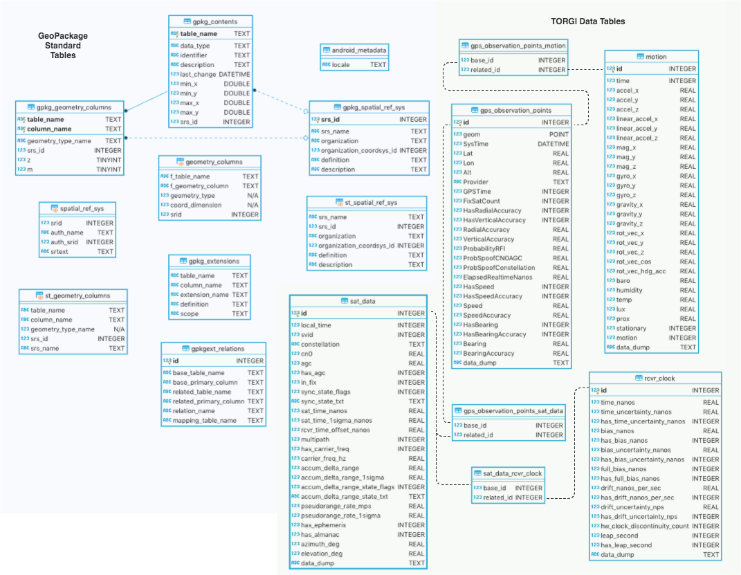
([View / Edit diagram in browser](https://www.draw.io/?url=https%3A%2F%2Fraw.githubusercontent.com%2Fsofwerx%2FTORGI%2Fmaster%2Fdocs%2FTORGI-GPKG-ERD.png%3Ft%3D0))
## DevOps
`docker-compose up`
Android .apk will be build inside the Docker container: (`torgi/build/outputs/apk/{debug|release}`)
See Dockerfile for build process. Requires Android build tools and [NGA GeoPackage Android SDK](https://ngageoint.github.io/geopackage-android/).
Travis CI - automated continuous integration: https://travis-ci.org/sofwerx/TORGI
## SOFWERX
[SOFWERX](https://www.sofwerx.org) was created under a Partnership Intermediary Agreement between [Doolittle Institute](www.defensewerx.org) and [U.S. Special Operations Command](https://www.socom.mil) in Tampa, Florida. We are a platform designed and operated to help solve challenging warfighter problems through increased collaboration and innovation. Our charter is twofold, to maintain a platform to accelerate delivery of innovative capabilities to USSOCOM, and to facilitate capability refinement through exploration, experimentation, and assessment of promising technology.
[](https://www.sofwerx.org)
[](https://twitter.com/sofwerx)