https://github.com/tyrasd/tortuosmity
:turtle: tortuOSMity
https://github.com/tyrasd/tortuosmity
openstreetmap openstreetmap-data visualization
Last synced: over 1 year ago
JSON representation
:turtle: tortuOSMity
- Host: GitHub
- URL: https://github.com/tyrasd/tortuosmity
- Owner: tyrasd
- License: isc
- Created: 2016-02-03T23:22:41.000Z (over 10 years ago)
- Default Branch: gh-pages
- Last Pushed: 2023-11-18T16:26:48.000Z (over 2 years ago)
- Last Synced: 2025-03-30T03:41:10.169Z (over 1 year ago)
- Topics: openstreetmap, openstreetmap-data, visualization
- Language: JavaScript
- Homepage: https://tyrasd.github.io/tortuosmity/
- Size: 12.3 MB
- Stars: 12
- Watchers: 2
- Forks: 0
- Open Issues: 1
-
Metadata Files:
- Readme: README.md
- License: LICENSE
Awesome Lists containing this project
README
tortuOSMity
===========
Calculates road-curviness from OpenStreetMap data using [osm-qa-tiles](http://osmlab.github.io/osm-qa-tiles/) and [tile-reduce](https://github.com/mapbox/tile-reduce).
Here, the curviness is defined as the average quotient between road length and end-to-end beeline distance of each osm way tagged as a highway (primary, …, residential) in each zoom-level 12 mercator tile. Each pixel in the output corresponds to one of these tiles and is colored according from violet (where the length quotient is near 1 which means almost straight roads) to red (quotient >= 2).
how to
------
$ npm install
$ node index.js "path to planet.mbtiles" > world.txt
$ gnuplot plot.gp
$ cd tiles
$ for i in {0..15}; do mkdir $i; done
$ convert ../world.png -crop 256x256 -set filename:tile "%[fx:page.x/256]/%[fx:page.y/256]" +repage +adjoin "%[filename:tile].png"
$ find -type f | parallel optipng
result
------
[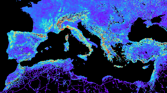](https://tyrasd.github.io/tortuosmity/)
[(click for world map)](https://tyrasd.github.io/tortuosmity/)
see also
--------
* https://github.com/rory/openstreetmap-bendy-roads
* https://github.com/adamfranco/curvature