https://github.com/z3tt/moabit_shapes
🗺 Cropped shapefiles for my home district Moabit (Berlin 21)
https://github.com/z3tt/moabit_shapes
berlin ggplot2 map rstats shapefiles simple-features
Last synced: 10 months ago
JSON representation
🗺 Cropped shapefiles for my home district Moabit (Berlin 21)
- Host: GitHub
- URL: https://github.com/z3tt/moabit_shapes
- Owner: z3tt
- Created: 2019-12-04T08:28:38.000Z (over 6 years ago)
- Default Branch: main
- Last Pushed: 2022-04-14T09:09:20.000Z (about 4 years ago)
- Last Synced: 2025-04-14T09:49:01.522Z (about 1 year ago)
- Topics: berlin, ggplot2, map, rstats, shapefiles, simple-features
- Language: HTML
- Homepage:
- Size: 111 MB
- Stars: 4
- Watchers: 1
- Forks: 1
- Open Issues: 0
-
Metadata Files:
- Readme: README.md
Awesome Lists containing this project
README
# 🗺 GIS Layers for Moabit aka Berlin 21
### Layers Included
This repository contains the following shapefiles cropped for my home district [Moabit](https://en.wikipedia.org/wiki/Moabit) in Berlin that is also known as "Berlin 21":
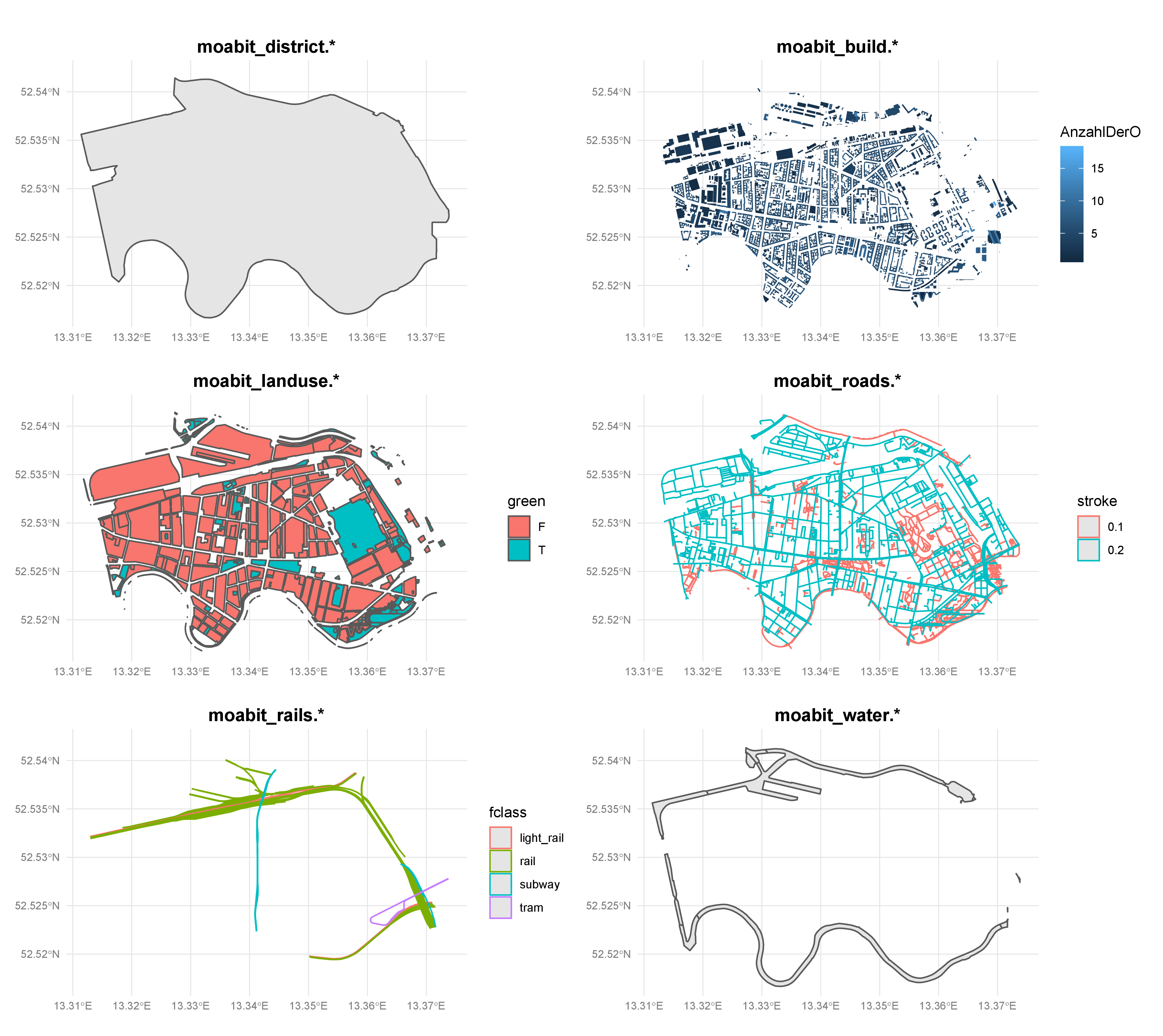
* `sf_moabit_district.shp`: District border of Moabit
* `sf_moabit_build.shp`: 4056 buildings
- `OBJECTID`: identification number
- `Gebaeudefu`: building function number
- `Gebaeude_1`: building type (in German)
- `AnzahlDerO`: number of above ground levels
- `AnzahlDerU`: number of below ground levels
- `Name`: buidling name (in German)
* `sf_moabit_landuse.shp`: Landuse classification
- `osm_id`: OSM identification number
- `code`: 4 digit code defining OSM feature class
- `fclass`: OSM feature class
- `name`: name of the feature
- `green`: green space classification, boolean variable
* `TRUE` if fclass one of "park", "recreation_ground", "cemetery", "scrub", "forest", "heath", "allotments" or "grass"
* `FALSE` otherwise
* `sf_moabit_roads.shp`: Road network
- `osm_id`: OSM identification number
- `code`: 4 digit code defining OSM feature class
- `fclass`: OSM feature class
- `name`: name of the feature
- `ref`: reference number
- `maxspeed`: speed limit
- `oneway`: boolean variable, `T` if feature is a oneway, `F` otherwise
- `bridge`: boolean variable, `T` if feature is a bridge, `F` otherwise
- `tunnel`: boolean variable, `T` if feature is a tunnel, `F` otherwise
- `stroke`: `0.1` in case of "path" and "footway", `0.2` otherwise
- `layer`: OSM layer
* `sf_moabit_rails.shp`: Railway tracks
- `osm_id`: OSM identification number
- `code`: 4 digit code defining OSM feature class
- `fclass`: OSM feature class
- `name`: name of the feature
* `sf_moabit_water.shp`: Water bodies
- `osm_id`: OSM identification number
- `code`: 4 digit code defining OSM feature class
- `fclass`: OSM feature class
- `name`: name of the feature
### Data Sources
Data sources that have been used:
* District borders ("Ortsteile"): [Berlin Open Data](https://daten.berlin.de/datensaetze/rbs-ortsteile-dezember-2014); uploaded: 2014-12-31
* Buildings: [Geoportal Berlin via ESRI DE Open Data](https://opendata-esri-de.opendata.arcgis.com/datasets/ecf431fd8c394ee1b2fd7d54563e7b81_0); uploaded: 2019-01-25
- Note: `Gebäude__Berlin.shp` and `Gebäude__Berlin.dbf` are not included here due to file size limits
* Landuse categories, road network, railsways and water bodies: [OpenStreetMap contributors via Geofabrik GmbH](https://download.geofabrik.de/europe/germany/berlin.html); last update: 2019-12-04
Other useful reosurces:
* A collection of (all?!) [Berlin's spatial units](https://lab.technologiestiftung-berlin.de/projects/spatial-units/en/) including districts, district areas, LORs, traffic cells, corridors, and ZIP code areas
* [BerlinOpenData](https://daten.berlin.de/) for a range of (potentially) interesting data about Berlin
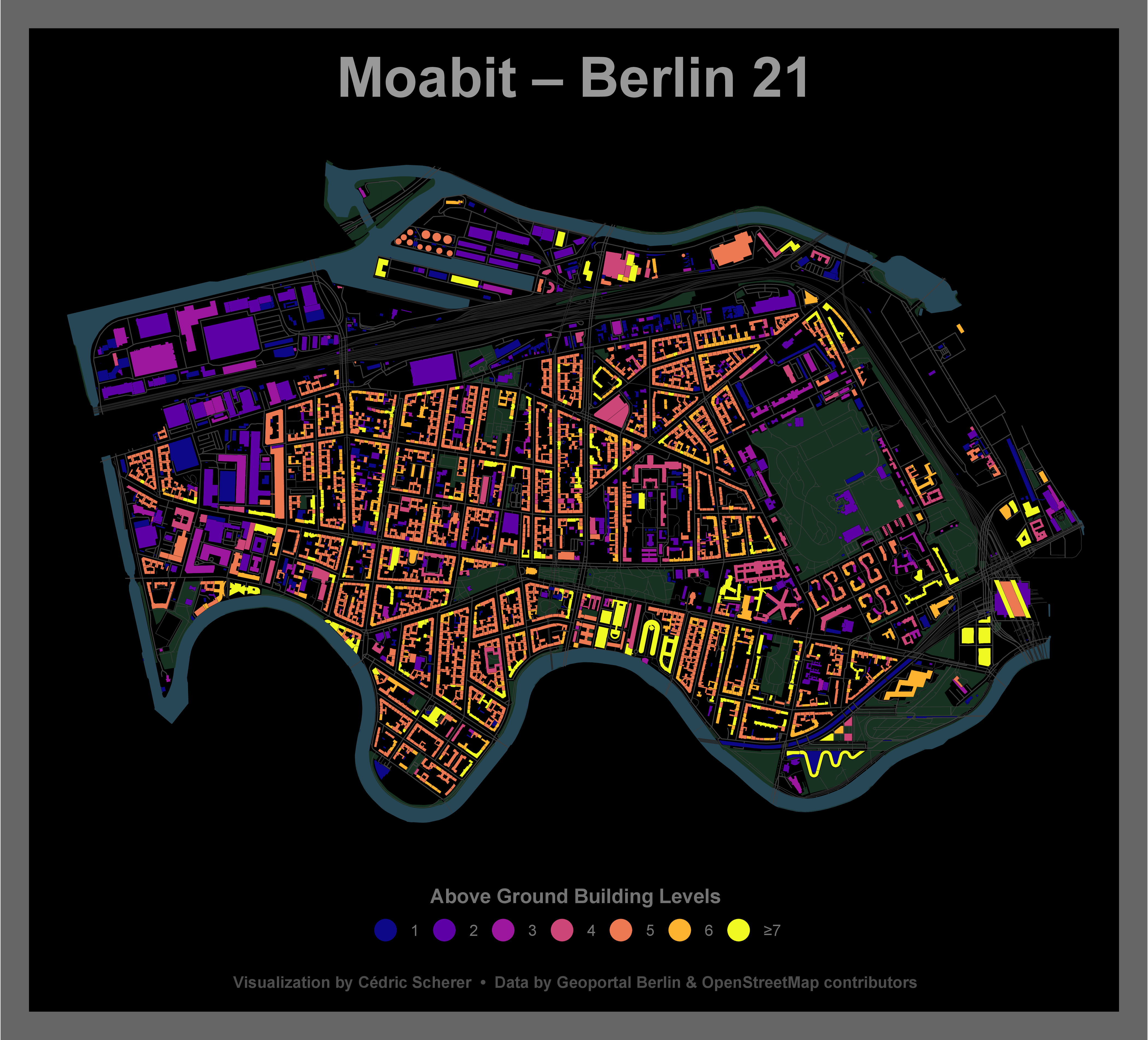
### Example Plot
***
Attribution-NonCommercial-ShareAlike 4.0 International (CC BY-NC-SA 4.0)

