Point cloud
A point cloud is a set of data points in space. The points represent a 3D shape or object. Each point has its set of X, Y and Z coordinates.
- GitHub: https://github.com/topics/point-cloud
- Wikipedia: https://en.wikipedia.org/wiki/Point_cloud
- Related Topics: 3d, lidar, mesh,
- Aliases: pointcloud, pointclouds, 3d-point-clouds,
- Last updated: 2026-11-16 00:26:21 UTC
- JSON Representation
https://github.com/pascalorg/editor
Open-source 3D architecture software for AECO, scan-to-BIM. Agent-friendly, browser-first, MCP, CLI.
3d 3d-scanning aec agent-skills ai-agents bim building-design cad cli floor-plan ifc interior-design local-first mcp mcp-server openbim point-cloud scan-to-bim threejs webgpu
Last synced: 15 Nov 2026

https://github.com/pointcloudlibrary/pcl
Point Cloud Library (PCL)
c-plus-plus computer-vision cpp pcl point-cloud pointcloud
Last synced: 15 Nov 2026

https://github.com/cvhub520/x-anylabeling
X-AnyLabeling: A lightweight, efficient, and unified cross-platform desktop application for annotating text, image, video, point cloud and multimodal data, combining versatile built-in tools with state-of-the-art AI models and flexible multi-format export.
ai computer-vision deep-learning groundingdino image-annotation-tool image-classification image-labeling-tool image-matting instance-segmentation machine-learning object-detection ocr onnxruntime paddlepaddle point-cloud pose-estimation rotated-object-detection sam vision-language-model yolo
Last synced: 15 Nov 2026

https://github.com/timzhang642/3d-machine-learning
A resource repository for 3D machine learning
3d 3d-reconstruction constructive-solid-geometries machine-learning mesh neural-networks papers point-cloud primitives voxel
Last synced: 15 Nov 2026

https://github.com/timzhang642/3D-Machine-Learning
A resource repository for 3D machine learning
3d 3d-reconstruction constructive-solid-geometries machine-learning mesh neural-networks papers point-cloud primitives voxel
Last synced: 14 Mar 2025
https://github.com/PointCloudLibrary/pcl
Point Cloud Library (PCL)
c-plus-plus computer-vision cpp pcl point-cloud pointcloud
Last synced: 20 Mar 2025
https://github.com/google/draco
Draco is a library for compressing and decompressing 3D geometric meshes and point clouds. It is intended to improve the storage and transmission of 3D graphics.
3d-graphics compression mesh point-cloud
Last synced: 18 Oct 2026

https://github.com/open-mmlab/mmdetection3d
OpenMMLab's next-generation platform for general 3D object detection.
3d-object-detection object-detection point-cloud pytorch
Last synced: 18 Oct 2026

https://google.github.io/draco/
Draco is a library for compressing and decompressing 3D geometric meshes and point clouds. It is intended to improve the storage and transmission of 3D graphics.
3d-graphics compression mesh point-cloud
Last synced: 11 Jul 2025
https://github.com/opendronemap/odm
A command line toolkit to generate maps, point clouds, 3D models and DEMs from drone, balloon or kite images. 📷
aerial-imagery drone photogrammetry point-cloud structure-from-motion uas
Last synced: 18 Oct 2026

https://github.com/cgal/cgal
The public CGAL repository, see the README below
algorithms arrange boolean-operations c-plus-plus cgal computational-geometry cpp geometry geometry-processing library mesh-processing meshes point-cloud polygon template-library triangulation voronoi-diagram
Last synced: 18 Oct 2026

https://github.com/cnr-isti-vclab/meshlab
The open source mesh processing system
3d 3d-models 3d-printing 3d-reconstruction 3d-scanning mesh mesh-editing mesh-generation mesh-processing mesh-simplification point-cloud triangle-mesh
Last synced: 18 Oct 2026

https://github.com/open-mmlab/openpcdet
OpenPCDet Toolbox for LiDAR-based 3D Object Detection.
3d-detection autonomous-driving object-detection point-cloud pv-rcnn pytorch
Last synced: 18 Oct 2026
https://github.com/charlesq34/pointnet
PointNet: Deep Learning on Point Sets for 3D Classification and Segmentation
classification geometry-processing neural-network point-cloud segmentation tensorflow
Last synced: 18 Oct 2026

https://github.com/CGAL/cgal
The public CGAL repository, see the README below
algorithms arrange boolean-operations c-plus-plus cgal computational-geometry cpp geometry geometry-processing library mesh-processing meshes point-cloud polygon template-library triangulation voronoi-diagram
Last synced: 14 Mar 2025
https://github.com/OpenDroneMap/OpenDroneMap
A command line toolkit to generate maps, point clouds, 3D models and DEMs from drone, balloon or kite images. 📷
aerial-imagery drone photogrammetry point-cloud structure-from-motion uas
Last synced: 11 Mar 2025
https://github.com/OpenDroneMap/ODM
A command line toolkit to generate maps, point clouds, 3D models and DEMs from drone, balloon or kite images. 📷
aerial-imagery drone photogrammetry point-cloud structure-from-motion uas
Last synced: 05 Apr 2025
https://github.com/open-mmlab/OpenPCDet
OpenPCDet Toolbox for LiDAR-based 3D Object Detection.
3d-detection autonomous-driving object-detection point-cloud pv-rcnn pytorch
Last synced: 20 Mar 2025

https://github.com/webodm/webodm
User-friendly, commercial-grade software for processing aerial imagery. ✈️ Download it for free!
drone maps photogrammetry point-cloud uav
Last synced: 19 Oct 2026

https://github.com/yanx27/pointnet_pointnet2_pytorch
PointNet and PointNet++ implemented by pytorch (pure python) and on ModelNet, ShapeNet and S3DIS.
classification modelnet point-cloud pointcloud pointnet pointnet2 pytorch s3dis segmentation shapenet visualization
Last synced: 19 Oct 2026

https://github.com/cdcseacave/openmvs
open Structure-fom-Motion and Multi-View Stereo reconstruction library
3d-reconstruction dense-point-cloud dense-reconstruction mesh multi-view-stereo openmvs patch-match point-cloud refinement semi-global-matching sgm spherical-camera stereo stereo-matching stereo-reconstruction-library stereo-vision structure-from-motion surface texture video-tracking
Last synced: 19 Oct 2026

https://github.com/charlesq34/pointnet2
PointNet++: Deep Hierarchical Feature Learning on Point Sets in a Metric Space
3d-shape classification deep-learning point-cloud segmentation
Last synced: 15 Nov 2026
https://github.com/yanx27/Pointnet_Pointnet2_pytorch
PointNet and PointNet++ implemented by pytorch (pure python) and on ModelNet, ShapeNet and S3DIS.
classification modelnet point-cloud pointcloud pointnet pointnet2 pytorch s3dis segmentation shapenet visualization
Last synced: 20 Mar 2025
https://github.com/gkjohnson/three-mesh-bvh
A BVH implementation to speed up raycasting and enable spatial queries against three.js meshes.
acceleration bounds bounds-hierarchy bvh distance geometry graphics intersection mesh pathtracing performance point-cloud pointcloud raycast raytracing three-js three-mesh-bvh threejs tree webvr
Last synced: 19 Oct 2026

https://github.com/pointcept/pointcept
Pointcept: Perceive the world with sparse points, a codebase for point cloud perception research. Latest works: Utonia (ICML'26), Concerto (NeurIPS'25), Sonata (CVPR'25 Highlight), PTv3 (CVPR'24 Oral)
Last synced: 19 Oct 2026

https://github.com/cdcseacave/openMVS
open Multi-View Stereo reconstruction library
3d-reconstruction dense-point-cloud dense-reconstruction mesh multi multi-view-stereo openmvs patch-match point-cloud refinement semi-global-matching sgm stereo stereo-matching stereo-reconstruction-library stereo-vision surface texture
Last synced: 18 Mar 2025
https://github.com/opendronemap/webodm
User-friendly, commercial-grade software for processing aerial imagery. ✈️
drone maps photogrammetry point-cloud uav
Last synced: 13 Feb 2026
https://github.com/OpenDroneMap/WebODM
User-friendly, commercial-grade software for processing aerial imagery. 🛩
drone maps photogrammetry point-cloud uav
Last synced: 15 Mar 2025
https://github.com/torch-points3d/torch-points3d
Pytorch framework for doing deep learning on point clouds.
deep-learning kpconv minkowskiengine point-cloud pointnet pytorch s3dis scannet segmentation
Last synced: 20 Oct 2026

https://github.com/cesiumgs/3d-tiles
Specification for streaming massive heterogeneous 3D geospatial datasets :earth_americas:
3d-models 3d-tiles geospatial gis gltf ogc photogrammetry point-cloud spatial-data specification terrain vector-data
Last synced: 19 Oct 2026

https://github.com/koide3/hdl_graph_slam
3D LIDAR-based Graph SLAM
hdl-graph-slam lidar point-cloud ros rslidar slam velodyne
Last synced: 19 Oct 2026

https://github.com/zhulf0804/3d-pointcloud
Papers and Datasets about Point Cloud.
autonomous-driving classification completion datasets detection generation monocular papers point-cloud registration segmentation
Last synced: 19 Oct 2026
https://github.com/zhulf0804/3D-PointCloud
Papers and Datasets about Point Cloud.
autonomous-driving classification completion datasets detection generation monocular papers point-cloud registration segmentation
Last synced: 14 Mar 2025
https://github.com/buaacyw/meshanything
[ICLR 2025] From anything to mesh like human artists. Official impl. of "MeshAnything: Artist-Created Mesh Generation with Autoregressive Transformers"
3d auto-regressive-model generative-ai generative-model iclr2025 large-language-models mesh mesh-generation point-cloud transformers
Last synced: 19 Oct 2026


https://github.com/CesiumGS/3d-tiles
Specification for streaming massive heterogeneous 3D geospatial datasets :earth_americas:
3d-models 3d-tiles geospatial gis gltf ogc photogrammetry point-cloud spatial-data specification terrain vector-data
Last synced: 07 May 2025
https://github.com/buaacyw/MeshAnything
From anything to mesh like human artists. Official impl. of "MeshAnything: Artist-Created Mesh Generation with Autoregressive Transformers"
3d auto-regressive-model generative-ai generative-model large-language-models mesh mesh-generation point-cloud transformers
Last synced: 07 May 2025
https://github.com/Pointcept/Pointcept
Pointcept: a codebase for point cloud perception research. Latest works: PTv3 (CVPR'24 Oral), PPT (CVPR'24), OA-CNNs (CVPR'24), MSC (CVPR'23)
Last synced: 20 Mar 2025
https://github.com/erikwijmans/pointnet2_pytorch
PyTorch implementation of Pointnet2/Pointnet++
hydra point-cloud pointnet2 pytorch pytorch-lightning
Last synced: 19 Oct 2026

https://github.com/facebookresearch/votenet
Deep Hough Voting for 3D Object Detection in Point Clouds
3d deep-learning object-detection point-cloud robotics voting
Last synced: 19 Oct 2026

https://github.com/koide3/fast_gicp
A collection of GICP-based fast point cloud registration algorithms
cpp cuda gicp gpu icp multithreading pcl point-cloud python registration scan-matching vgicp
Last synced: 19 Oct 2026
https://github.com/liangliangnan/easy3d
A lightweight, easy-to-use, and efficient library for processing and rendering 3D data (C++ & Python)
3d-modeling computer-graphics data-structure geometry-processing graph mesh opengl point-cloud polyhedral-mesh reconstruction rendering shader surface-mesh viewer visualization
Last synced: 19 Oct 2026
https://github.com/charlesq34/frustum-pointnets
Frustum PointNets for 3D Object Detection from RGB-D Data
3d deep-learning object-detection point-cloud robotics
Last synced: 19 Oct 2026
https://github.com/ankitdhall/lidar_camera_calibration
ROS package to find a rigid-body transformation between a LiDAR and a camera for "LiDAR-Camera Calibration using 3D-3D Point correspondences"
3d-points aruco-markers calibration camera camera-calibration camera-frame data-fusion hesai lidar lidar-camera-calibration lidar-frame point-cloud point-clouds ros ros-kinetic ros-melodic stereo-cameras velodyne
Last synced: 19 Oct 2026

https://github.com/erikwijmans/Pointnet2_PyTorch
PyTorch implementation of Pointnet2/Pointnet++
hydra point-cloud pointnet2 pytorch pytorch-lightning
Last synced: 20 Mar 2025
https://github.com/v2ai/det3d
World's first general purpose 3D object detection codebse.
3d-object-detection autonomous-driving deep-learning kitti nuscenes object-detection point-cloud pytorch
Last synced: 19 Oct 2026

https://github.com/fwilliams/point-cloud-utils
An easy-to-use Python library for processing and manipulating 3D point clouds and meshes.
chamfer-distance geometry hausdorff hausdorff-distance hausdorff-measure lloyd-relaxation mesh nanoflann nearest-neighbor nearest-neighbors numpy optimal-transport point-cloud poisson poisson-disc-sampling poisson-disk-sampling python sampling sinkhorn sinkhorn-distance
Last synced: 19 Oct 2026

https://github.com/keijiro/pcx
Point cloud importer & renderer for Unity
3d-scan graphics point-cloud shader unity unity3d
Last synced: 19 Oct 2026

https://github.com/V2AI/Det3D
World's first general purpose 3D object detection codebse.
3d-object-detection autonomous-driving deep-learning kitti nuscenes object-detection point-cloud pytorch
Last synced: 20 Mar 2025
https://github.com/yangyanli/pointcnn
PointCNN: Convolution On X-Transformed Points (NeurIPS 2018)
autonomous-driving classification convolutional-neural-networks deep-neural-networks machine-learning point-cloud pointcloud robotics scannet segmentation shapenet
Last synced: 19 Oct 2026

https://github.com/yangyanli/PointCNN
PointCNN: Convolution On X-Transformed Points (NeurIPS 2018)
autonomous-driving classification convolutional-neural-networks deep-neural-networks machine-learning point-cloud pointcloud robotics scannet segmentation shapenet
Last synced: 20 Mar 2025
https://github.com/LiangliangNan/Easy3D
A lightweight, easy-to-use, and efficient C++ library for processing and rendering 3D data
3d-modeling computer-graphics data-structure geometry-processing graph mesh opengl point-cloud polyhedral-mesh reconstruction rendering shader surface-mesh viewer visualization
Last synced: 20 Mar 2025
https://github.com/keijiro/Pcx
Point cloud importer & renderer for Unity
3d-scan graphics point-cloud shader unity unity3d
Last synced: 07 May 2025
https://github.com/xtreme1-io/xtreme1
Xtreme1 is an all-in-one data labeling and annotation platform for multimodal data training and supports 3D LiDAR point cloud, image, and LLM.
3d-annotation annotation annotation-tool computer-vision image-annotation image-classification image-labelling-tool labeling-tool lidar-annotation lidar-camera-fusion lidar-object-detection lidar-object-tracking multimodal point-cloud rlhf
Last synced: 19 Oct 2026

https://github.com/prbonn/depth_clustering
:taxi: Fast and robust clustering of point clouds generated with a Velodyne sensor.
catkin clustering depth depth-clustering depth-image fast lidar pcl point-cloud range range-image real-time robotics ros segmentation velodyne velodyne-sensor
Last synced: 19 Oct 2026

https://github.com/mikeroyal/photogrammetry-guide
Photogrammetry Guide. Photogrammetry is widely used for Aerial surveying, Agriculture, Architecture, 3D Games, Robotics, Archaeology, Construction, Emergency management, and Medical.
3d-reconstruction camera cesium drones geometry geospatial gis image-processing lidar map multiview-stereo photogrammetry point-cloud pointcloud rendering sfm slam spatial-data structure-from-motion unreal-engine
Last synced: 19 Oct 2026

https://github.com/hku-mars/livox_camera_calib
This repository is used for automatic calibration between high resolution LiDAR and camera in targetless scenes.
Last synced: 19 Oct 2026

https://github.com/mikeroyal/Photogrammetry-Guide
Photogrammetry Guide. Photogrammetry is widely used for Aerial surveying, Agriculture, Architecture, 3D Games, Robotics, Archaeology, Construction, Emergency management, and Medical.
3d-reconstruction camera cesium drones geometry geospatial gis image-processing lidar map multiview-stereo photogrammetry point-cloud pointcloud rendering sfm slam spatial-data structure-from-motion unreal-engine
Last synced: 07 Apr 2025
https://github.com/patrick-llgc/learning-deep-learning
Paper reading notes on Deep Learning and Machine Learning
3d-object-detection 3d-object-recognition cnn computer-vision deep-learning literature-review machine-learning medical medical-imaging paper paper-reading paper-review point-cloud reinforcement-learning
Last synced: 19 Oct 2026

https://github.com/PRBonn/depth_clustering
:taxi: Fast and robust clustering of point clouds generated with a Velodyne sensor.
catkin clustering depth depth-clustering depth-image fast lidar pcl point-cloud range range-image real-time robotics ros segmentation velodyne velodyne-sensor
Last synced: 20 Mar 2025
https://github.com/stereolabs/zed-sdk
⚡️The spatial perception framework for rapidly building smart robots and spaces
3d-reconstruction computer-vision depth-camera depth-estimation human-pose-estimation machine-learning object-detection perception point-cloud realtime slam stereo stereo-vision stereolabs zed zed-camera zed-x zed2
Last synced: 19 Oct 2026

https://github.com/xharlie/pointnerf
Point-NeRF: Point-based Neural Radiance Fields
3d 3d-reconstruction cvpr2022 differentiable-rendering graphics implicit-functions multiview-stereo mvs nerf neural-radiance-fields neural-renderer neural-rendering point-based-graphics point-cloud radiance-field reconstruction scannet scene-reconstruction tanks-and-temples volume-rendering
Last synced: 19 Oct 2026

https://github.com/kzampog/cilantro
A lean C++ library for working with point cloud data
3d 3d-visualization clustering convex convex-hull icp iterative-closest-point k-means mds mean-shift model-fitting non-rigid-registration pca point-cloud ransac reconstruction registration rgbd segmentation spectral-clustering
Last synced: 19 Oct 2026

https://github.com/url-kaist/patchwork-plusplus
Patchwork++: Fast and robust ground segmentation method for 3D LiDAR scans. @ IROS'22
3d-lidar detection ground ground-detection ground-removal ground-segmentation lidar point-cloud segmentation
Last synced: 19 Oct 2026

https://github.com/Xharlie/pointnerf
Point-NeRF: Point-based Neural Radiance Fields
3d 3d-reconstruction cvpr2022 differentiable-rendering graphics implicit-functions multiview-stereo mvs nerf neural-radiance-fields neural-renderer neural-rendering point-based-graphics point-cloud radiance-field reconstruction scannet scene-reconstruction tanks-and-temples volume-rendering
Last synced: 20 Mar 2025
https://github.com/drprojects/superpoint_transformer
Official PyTorch implementation of Superpoint Transformer [ICCV'23], SuperCluster [3DV'24 Oral], and EZ-SP [ICRA'26]
3d 3dv2024 deep-learning efficient fast graph-clustering hierarchical iccv2023 lightweight panoptic-segmentation partition partitioning point-cloud pytorch semantic-segmentation superpoint transformer
Last synced: 19 Oct 2026

https://github.com/neka-nat/cupoch
Robotics with GPU computing
collision-detection cuda distance-transform gpgpu gpu jetson occupancy-grid-map odometry pathfinding point-cloud pybind11 python registration robotics ros triangle-mesh visual-odometry voxel
Last synced: 19 Oct 2026

https://github.com/internrobotics/pointllm
[ECCV 2024 Best Paper Candidate & TPAMI 2025] PointLLM: Empowering Large Language Models to Understand Point Clouds
3d chatbot foundation-models gpt-4 large-language-models llama multimodal objaverse point-cloud pointllm representation-learning vision-and-language
Last synced: 19 Oct 2026

https://github.com/k3d-tools/k3d-jupyter
WebGL 3D plotting for Jupyter: meshes, isosurfaces, volumes, voxels and point clouds from NumPy arrays, with a path-traced cinematic renderer.
3d anywidget isosurface jupyter jupyter-widget numpy path-tracing point-cloud scientific-visualization visualization volume-rendering voxel webgl
Last synced: 19 Oct 2026

https://github.com/graspnet/graspnet-baseline
Baseline model for "GraspNet-1Billion: A Large-Scale Benchmark for General Object Grasping" (CVPR 2020)
3d deep-learning grasping graspnet-1billion point-cloud robotics
Last synced: 19 Oct 2026

https://github.com/uhlik/bpy
blender python scripts
addon blender blender-addon blender-scripts opengl photogrammetry ply-files point-cloud point-cloud-visualizer time-tracker uv-mapping wavefront-obj zbrush
Last synced: 19 Oct 2026

https://github.com/nv-tlabs/nksr
[CVPR 2023 Highlight] Neural Kernel Surface Reconstruction
3d-reconstruction computer-vision graphics neural-kernel point-cloud
Last synced: 19 Oct 2026

https://github.com/koide3/interactive_slam
Interactive Map Correction for 3D Graph SLAM
gui hdl-graph-slam lidar point-cloud ros slam velodyne
Last synced: 24 Oct 2025
https://github.com/neka-nat/probreg
Python package for point cloud registration using probabilistic model (Coherent Point Drift, GMMReg, SVR, GMMTree, FilterReg, Bayesian CPD)
3d coherent-point-drift dual-quaternion dual-quaternion-skinning expectation-maximization-algorithm filterreg gaussian-mixture-models non-rigid-registration open3d point-cloud point-cloud-registration registration rigid-transformations variational-inference
Last synced: 15 May 2025
https://github.com/xeokit/xeokit-sdk
3D BIM IFC Viewer SDK for AEC engineering applications. Open Source JavaScript Toolkit based on pure WebGL for top performance, real-world coordinates and full double precision
3d-tiles 3d-viewers bim bim-viewer buildingsmart geometry geospatial gis ifc ifc-viewer javascript-viewer las-viewer laz-viewer online-viewer point-cloud point-cloud-viewer viewer-sdk web-viewer webgl webgl-viewer
Last synced: 27 May 2026

https://github.com/andyzeng/3dmatch-toolbox
3DMatch - a 3D ConvNet-based local geometric descriptor for aligning 3D meshes and point clouds.
3d 3d-deep-learning 3dmatch artificial-intelligence computer-vision deep-learning geometry-processing point-cloud rgbd vision
Last synced: 16 May 2025

https://github.com/InternRobotics/PointLLM
[ECCV 2024 Best Paper Candidate & TPAMI 2025] PointLLM: Empowering Large Language Models to Understand Point Clouds
3d chatbot foundation-models gpt-4 large-language-models llama multimodal objaverse point-cloud pointllm representation-learning vision-and-language
Last synced: 20 Aug 2025
https://github.com/xinge008/Cylinder3D
Rank 1st in the leaderboard of SemanticKITTI semantic segmentation (both single-scan and multi-scan) (Nov. 2020) (CVPR2021 Oral)
cvpr2021 lidar-point-cloud lidar-segmentation nuscenes panoptic-segmentation point-cloud semantic-segmentation semantickitti
Last synced: 20 Mar 2025

https://github.com/ChaofanTao/Autoregressive-Models-in-Vision-Survey?tab=readme-ov-file
[TMLR 2025🔥] A survey for the autoregressive models in vision.
acceleration autoregressive computer-vision deep-learning diffusion embodied-ai image-generation medical-ai motion-prediction multimodal point-cloud survey text-to-image video-generation
Last synced: 23 Jul 2026

https://github.com/tomas789/kitti2bag
Convert KITTI dataset to ROS bag file the easy way!
converter kitti kitti-data kitti-dataset odometry point-cloud ros rosbag tool
Last synced: 12 May 2025

https://github.com/koide3/ndt_omp
Multi-threaded and SSE friendly NDT algorithm
matching multithreading ndt ndt-algorithm pcl point-cloud registration ros scan-matching
Last synced: 16 May 2025
https://github.com/loicland/superpoint_graph
Large-scale Point Cloud Semantic Segmentation with Superpoint Graphs
clustering large-scale lidar partition ply-files point-cloud pytorch segmentation semantic semantic-segmentation superpoint-graphs
Last synced: 07 May 2025

https://github.com/ChaofanTao/Autoregressive-Models-in-Vision-Survey
[TMLR 2025🔥] A survey for the autoregressive models in vision.
acceleration autoregressive computer-vision deep-learning diffusion embodied-ai image-generation medical-ai motion-prediction multimodal point-cloud survey text-to-image video-generation
Last synced: 11 Jun 2026
https://github.com/OpenRobotLab/PointLLM
[ECCV 2024 Best Paper Candidate] PointLLM: Empowering Large Language Models to Understand Point Clouds
3d chatbot foundation-models gpt-4 large-language-models llama multimodal objaverse point-cloud pointllm representation-learning vision-and-language
Last synced: 20 Mar 2025

https://github.com/antao97/dgcnn.pytorch
A PyTorch implementation of Dynamic Graph CNN for Learning on Point Clouds (DGCNN)
classification point-cloud pytorch segmentation
Last synced: 20 Mar 2025

https://github.com/leomariga/pyRANSAC-3D
Python library for fitting 3D primitive shapes to point clouds with RANSAC. Detect planes, spheres, cylinders, cuboids, circles, and lines.
3d-reconstruction cuboid cylinder geometry lidar open3d plane-detection planes point-cloud ransac ransac-algorithm segmentation shape-detection shape-fitting slam
Last synced: 12 Sep 2026

https://github.com/mit-han-lab/pvcnn
[NeurIPS 2019, Spotlight] Point-Voxel CNN for Efficient 3D Deep Learning
frustum-pointnet frustum-pointnets kitti point-cloud point-voxel-cnn pointnet pointnet2 pvcnn pytorch s3dis shapenet
Last synced: 20 Mar 2025

https://github.com/luost26/diffusion-point-cloud
:thought_balloon: Diffusion Probabilistic Models for 3D Point Cloud Generation (CVPR 2021)
cvpr cvpr2021 generation generative-model point-cloud
Last synced: 04 Apr 2025

https://github.com/hku-mars/std
A 3D point cloud descriptor for place recognition
lidar-slam loop-closure loop-detection place-recognition point-cloud
Last synced: 04 Apr 2025
https://github.com/r-lidar/lidr
Airborne LiDAR data manipulation and visualisation for forestry application
als forestry las laz lidar point-cloud r remote-sensing
Last synced: 27 Mar 2026
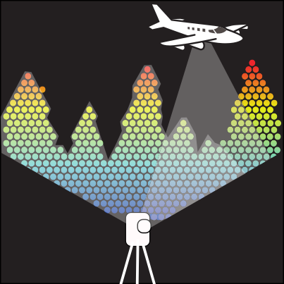
https://github.com/walzimmer/3d-bat
3D Bounding Box Annotation Tool (3D-BAT) Point cloud and Image Labeling
2d 3d 3d-object-detection active-learning annotation automatic autonomous-driving bounding-box detection interpolation javascript mechanical-turk multi-platform multi-view point-cloud pointcloud semi-automatic surround tool web
Last synced: 20 Mar 2025

https://github.com/r-lidar/lidR
Airborne LiDAR data manipulation and visualisation for forestry application
als forestry las laz lidar point-cloud r remote-sensing
Last synced: 20 Mar 2025
https://github.com/meshinspector/meshlib
Mesh processing library
3d cpp cross-platform distance-map geometry library mesh mesh-analysis mesh-boolean mesh-decimation mesh-processing mesh-registration mesh-segmentation mesh-smoothing point-cloud pointcloud pointcloud-triangulation python voxel voxel-segmentation
Last synced: 26 Jan 2026

https://github.com/leomariga/pyransac-3d
A python tool for fitting primitives 3D shapes in point clouds using RANSAC algorithm
3d-reconstruction cuboid cylinder open3d plane-detection planes point-cloud ransac ransac-algorithm segmentation
Last synced: 09 Apr 2025
https://github.com/MeshInspector/MeshLib
Mesh processing library
3d cpp cross-platform distance-map geometry library mesh mesh-analysis mesh-boolean mesh-decimation mesh-processing mesh-registration mesh-segmentation mesh-smoothing point-cloud pointcloud pointcloud-triangulation python voxel voxel-segmentation
Last synced: 16 Apr 2025
https://github.com/nv-tlabs/NKSR
[CVPR 2023 Highlight] Neural Kernel Surface Reconstruction
3d-reconstruction computer-vision graphics neural-kernel point-cloud
Last synced: 17 Apr 2025
https://github.com/paddlepaddle/paddle3d
A 3D computer vision development toolkit based on PaddlePaddle. It supports point-cloud object detection, segmentation, and monocular 3D object detection models.
3d apollo autodrive bev caddn centerpoint hrnet kitti-dataset nuscenes point-cloud pointpillars smoke squeezeseg three-dimension-vision waymo-open-dataset
Last synced: 14 May 2025

https://github.com/qinzheng93/GeoTransformer
[CVPR2022] Geometric Transformer for Fast and Robust Point Cloud Registration
attention-mechanism computer-vision deep-learning neural-network point-cloud point-cloud-registration pytorch registration transformer
Last synced: 20 Mar 2025
